Cartographica Neerlandica Background for Ortelius Map No. 219
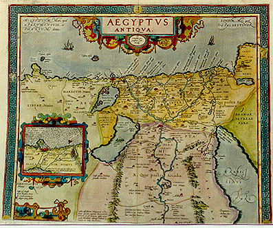
Title: AEGYPTVS | ANTIQVA | "Ex | Conatibus geo:|graphicis Ab. | Ortelij". [Ancient Egypt, from the geographical efforts of Abraham Ortelius]. (North half; Inset: Alexandria and surroundings, 93 x 116 mm).
Plate size: 393 x 481 mm.
Scale: 1 : 1,000,000
Identification number: Ort 219 (Koeman/Meurer: 4P, Karrow: 1/163, van der Krogt AN: 8650H:1:31A).
Occurrence in Theatrum editions and page number:
1584L3Addblank (100 copies printed) (identical to 1584L, but here without page number; last line, left aligned: Plinius,Marcellinus,alijque,eas satis luculenta oratione describunt.),
1584L109 (750 copies printed) (identical to 1584L3Add, but here with page number 109; last line, left aligned: Plinius,Marcellinus,alijque,eas satis luculenta oratione describunt.),
1584G3Add2 in upper right corner (75 copies printed) (last line, left aligned, in Gothic script like most of the text: Strabo/Plinius/Marcellinus und andere deutlich genug.),
1585F3Add23 (75 copies printed) (last line, left aligned: Strabon, Pline, Marcellin, & plusieurs autres , qui les descriuent assez au vif.),
1587F107 (250 copies printed) (last line, left aligned: sieurs autres , qui les descriuent assez au vif.),
1592L20 (525 copies printed) (last line, left aligned: cellinos, alijque, eas satis luculenta oratione describunt.).
Approximate number of copies printed: 1775.
States: 219.1 as described;
219.2: in 1592, in the textblock in lower left, last line third word "trisu" (which is meaningless) changed to "tribu" [tribe].
Cartographic sources: Ortelius own two-sheet map of Ancient Egypt, dedicated to the humanist and medical doctor Scipio Fabio from Bologna, which appeared in 1565, and for which Ortelius mentions as sources Diodorus, Herodotos, Strabo and Plinius (Meurer p. 21-22).
References: G. Schilder (1987) "Monumenta Cartographica Neerlandica" II, Canaletto, p. 8-9. P.H. Meurer "Ortelius as the Father of Historical Cartography", p. 133-159 in: M. van den Broecke, P. van der Krogt and P.H. Meurer (eds.) "Abraham Ortelius and the First Atlas", HES Publishers, 1998.
Remarks: This map, together with Ort 220, was replaced by a one sheet map, plate Ort 221, in 1595L.
For questions/comments concerning this page, please e-mail info@orteliusmaps.com.