Cartographica Neerlandica Background for Ortelius Map No. 218
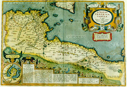
Title: AFRICAE | PROPRIAE | TABVLA, | "In qua", | Punica regna vides;| Tyrios, et Agenoris | urbem. | "Illustri ac Amplissimo viro Domino | Christophoro ab Assonleville: Equiti | aurato; Altevillæ domino: Regis Ca:|tholici Consiliario primario. Abrahamus | Ortelius dedicabat, lubens merito". [A map of Africa proper, on which you see the Punic kingdom, Tyrios and the city of Agenor. Dedicated to the illustrious and honourable gentleman lord Christophorus from Assonleville. Honoured knight, ruler of Altevilla, first councillor of our catholic king, by Abraham Ortelius because of his great merits]. (Cartouche lower right:) EX CONATIBVS GEOGRAPHICIS | ABRAHAMI ORTELII.| "Cum priuilegio Imperiali, Regio, et Bel:|gico, ad decennium. 1590". [From the geographical efforts of Abraham Ortelius. With an imperial, Royal and Belgian privilege for ten years. 1590]. (Cartouche bottom centre: three colums of placenames of uncertain location). (Inset:) "Sinus Carthaginensis, ipsæque ur:|bis, atque locorum aliquot vicino:|rum plenior descriptio". [A full depiction of the Carthago gulf, the city of Carthago, and of some places in the vicinity]. (Upper centre:) "Melita, quæ Maltaria Anton. | Carthaginensium colonia. | D. Pauli naufragio insignis". [The isle of Melita, Antoninus calls it Maltaria. It became famous because of the shipwreck of St. Paulus]. (Centre:) Sinus III, "diuiditur in geminos; duarum Syrtium | vadoso ac reciproco mari diros. Plinius". [The third gulf is divided into two parts; of these two the Syrtian sea is full of shallow places, and at ebb tide very dangerous]. (Lower right:) CINYPS "Regio totius | Africæ fertilißima | pulcherrimaque". [Cynips, the most fertile and beautiful region of Africa]. (Lower right:) Lotophagi, quos quidam | Alachroas vocant. | et Camarinæos. [The Lotos-eaters, by some called Alachroæ and also Camarinei.] (Lower right:) "Hesperidum horti, | hic à Plinio sta:|tuuntur". [The gardens of the Hesperides are placed here by Plinius]. (Lower right:) Macæi Syrtitæ. Macæ | et Maces sunt alijs. [The Syrtitian Macæi. The Macæ and Maces are different people]. More text blocks in Topographical Names.
Plate size: 335 x 487 mm.
Scale: 1 : 5,000,000.
Identification number: Ort 218 (Koeman/Meurer: 14P, Karrow: 1/183, van der KrogtAN: 8610H:31).
Occurrence in Theatrum editions and page number:
1590L4Addblank (100 copies printed) (identical in text and typesetting with 1592L, but here without page number; last line, left aligned, : fulmen, ceteráque deorum dearumque quæ huic adpinguntur insignia. At de hac Dea à me,qui geographica institui,fortè nimis multa.),
1591G4Addblank (75 copies printed) (last line, left aligned, not in Gothic script like most of the rest of the text: Persicorum.),
1592L22 (525 copies printed) (identical in text and typesetting with 1590L4Add, but here with page number 22; last line, left aligned: fulmen, ceteráque deorum dearumque quæ huic adpinguntur insignia. At de hac Dea à me,qui geographica institui,fortè nimis multa.),
1595Lc (500 copies printed) (last line first text page: spaniam ad Pyrenæos vsque montes potita fuit.Adeò,vt Appianus scriptor grauissimus,huius Imperium,viribus Græcorum,opibus ; last line second text page, left aligned: hac Dea à me,qui geographica institui,fortè nimis multa.),
1601Lxxx (200 copies printed) (last line first text page, right aligned: ginis ; last line second text page, left aligned: nostram. At de hac Dea à me, qui geographica institui, fortè nimis multa.),
1602G28 (250 copies printed) (last line, left aligned, in Gothic script like the entire text: mehr/davon nur eun eiteler Nahm.Von dem Volck aber dieses Africæ/von wannen sie in dieser landtschafft kommen/schreibt Procopius lib. secundo Persicorum.),
1603L rarely xxx, mostly xxxij (300 copies printed) (text and page number, but not typesetting, identical to the edition 1609/1612S/L; this 1603L edition has two text pages, the 1609/1612S/L has only one text page; last line first text page, right aligned: eius ; last line second text page, left aligned: Deam hanc nostram. At de hac Dea à me , qui geographica institui , fortè nimis multa.),
1606Exxx (300 copies printed) (last line, first text page of two, full width: "it the" temple of Iuno, "as the famous Poet" Virgil "hath left recorded : Item,the" temple of Elisa, "as" Siluis Italicus "testifieth. What places afterward"|Iustinian),
1608/1612Ixxxij (300 copies printed) (last line first text page, right aligned: Dione, ; last line second text page, right aligned, in cursive script like the bottom half of this page: "grafia ,forse anco troppo è discorso".),
1609/1612Sxxxij (text in Latin) = 1609/1612Lxxxij (600 copies printed) (text and page number, but not typesetting, identical to 1603L. However, this edition has only one text page whereas 1603L has two text pages; last line, left aligned: nihil autem ad Deam hanc nostram. At de hac Dea à nec,qui geographica insitui, fortè nimis multa.),
1618BertiusIII (200 copies printed) (last line, right aligned, first text page: reuerenda; last line second text page, full width: Nihil autem ille ad Deam hãc nostram.Ad de hac Dea à me,qui Geographica institui,fortè nimis multa.),
1624P/1641Sxxxvj (1025 copies printed) (last line second column first text page, right aligned: scribit ; last line second column second text page, left aligned: phica institui,fortè nimis multa.).
Approximate number of copies printed: 4375.
States: 218.1 as described;
218.2: in 1624 ornamental changes were made on the lower left and upper right cartouche. Top right circle around text has at 9 o’clock received oblique hatching from upper left to lower right, where it used to have horizontal hatching. Around the lower left inset map of Carthago the lower right corner now has diagonal hatching from lower left to upper right, where in the first state the hatching was mostly horizontal.
Cartographic sources: made by Ortelius on the basis of modern information from Gastaldi's Africa map (Meurer p. 87-88, p. 151) and ancient knowledge from Diodorus Siculus, Plinius, Vergilius, Appianus, Halicarnasseus, Athenæus and Herodotos.
Remarks: Bertius bought a number of sheets with this map and included the map in his historical 1618 atlas "Theatrum Geographiæ Veteris", using the text of the 1609/1612S/L Theatrum, but reset.
The extensive text deals mostly with the city of Carthago (see text) and its final destruction by the Romans.
For questions/comments concerning this page, please e-mail info@orteliusmaps.com.