Cartographica Neerlandica Background for Ortelius Map No. 187
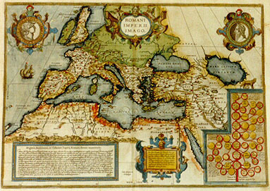
Title: ROMANI | IMPERII | IMAGO. [Image of the Roman Empire]. (Middle bottom:) "Cum Gratia et | Priuilegio". [With grace and privilege]. (Lower left and middle two cartouches with 14 lines [viz]:) Originis, Incrementi, et Culminis Imperij Romani, breuis enumeratio. "Primo sub Regibus septem, Romulo, Seruio, etc. per annos ducentos & tres supra quadraginta, non amplius quam usque Portum, atque Hosti:|am, intra decimum octauum miliariű Romanum proceßit Imperium Sub Consulib. verň, inter quos interdum Dictatores, et Decemuiri, ac Tribuni | militares fuerunt, per annos quadrigentos & septem supra quadraginta, usque trăs Padum Italia est capta: Africa Hispanićque subactć: Gallia, et | Britannia tributarić sunt factć: Illyrici, Histri, Liburni, Dalmatć, sunt domiti. ad Achaiam transitum est: Macedones expugnati: cum Dardanis, | Moesis et Thracibus est bellatum. ad Danubium est peruentum: ac in Asia (pulso Antiocho) primum pedem posuerunt Romani. Mithrida:|te victo, regnum Ponti est captum, cum Armenia minori quam idem tenuerat: in Mesopotamiam progressum est; & cum Parthis foedus initum; contra | Carduenos, & Saracenos ac Arabas pugnatum: Judća omnis victa: Cilicia et Sria, in potestatem redacta: ac tandem in Aegyptum peruentum: Sub Impe:|ratoribus autem, a Diuo Augusto nempe, ad Theodosij superioris, et Honorij ac Arcadij eius filiorum tempora, per annos quadrigentos & | quadraginta, Cantabri, Astures, totaque Hispania sub iugum mißa est. Alpes maritimć, Coccićque et Rhetić, Noricum Pannonić et Moesić, Imperio | acceßerunt. Omnis ora Danubij in Prouincias est redacta. Pontus omnis, et Armenia Maior, Aßyria, Arabia et Ćgyptus, in Im:|perij Romani iura conceßerunt. Atque hoc modo his Principibus viris, & populi Romani virtute, ac immortali eorű gloria, hoc Augustißimű Im:|perium ad summű fastigium perductum fuit; Cuius limites fuere ad Occidentę Oceanus, ŕ Septentrione Rhenus et Danubius, ab Oriente Tigris, | ŕ Meridie Atlas mons. quć omnia in hact tabula ob oculos (historić candidatis) ponuntur". [A short list of the origins, growth and culmination of the Roman Empire: At first, under the seven kings called Romulus, Servius etc., the Roman Empire extended for 243 years no further than to Portus and Ostia within a radius of 18 miles. However, under the consuls, in some cases including dictators, groups of ten men, and military tribunes, Italy has been conquered in 447 years all the way beyond the river Po; Africa and Spain have been subdued, Gallia and Britannia have been conquered; the Illyrians, Histrians, Liburnians and Dalmatians have been overrun; Greece has been invaded, the Macedonians have been beaten; wars have been waged against the Dardanians, the Mśsians and the Thracians; the Danube has been reached and the Romans have made their first conquests in Asia by winning Antiochus; When Mithridates had been defeated they occupied the kingdom of Pontus and at the same time the smaller province of Armenia, which was under his rule. The Romans proceeded to Mesopotamia and struck a treaty with the Parths. They entered into combat with the Carduanians, Saracenes and Arabs. They conquered all of Judea. They brought Cilicia and Syria under their rule. Finally, they invaded Egypt. However, when the emperors ruled, that is to say from the time of divine Augustus until the time of Theodosius the Great and his sons Honorius and Arcadius, they brought under their rule in the course of 440 years the Cantabrians, the Asturians, and all the rest of Spain. The coastal areas, the Alps, Coccia and Rhetia, Noricum, Pannonia and Moesia have augmented their power. The entire Danube area has been divided into provinces. The entire Pontus, Greater Armenia, Assyria, Arabia and Egypt have come under Roman law, and thus, thanks to the exertions of their commanders, and through the valiant behaviour of the Roman population, and in immortal glory, they have attained the highest stage for this most elevated empire, of which the borders in the West are the ocean, in the North the Rhine and the Danube, in the East the Tigris, and in the South the Atlas mountain range. All this is shown on this map for the benefit of those studying history].
(Cartouche upper left:) ROMA TVVM NOMEN TERRIS FATALE REGENDIS [around the portrait of Tibullus, who wrote this quote (2.5.57): Rome, your race is destined to rule the world].
(Cartouche upper right: ROMVLO VRBIS AETERNAE CONDITORI [For Romulus, the founder of the eternal city.]
(Cartouche centre bottom right, with 8 lines of text, viz: "Ex Liuio, Dionysio, & Plutarcho, hanc ge:|nealogiam septem Regum desumpsimus, at:|que huic tabulć in historić Romanć studioso:|rum gratiam adiecimus. In qua maxima linea | est Regum: mediocres sunt coniugum: minimć | verň filiorum filiarumque. Circuli duplicibus cir:|cumferentijs descripti, masculos denotant; | simplicibus autem, foeminas". [We have taken this genealogy of the seven kings from Livius, Dionysius and Plutarchus, for the benefit of those who have an interest in Roman history. The main line of descent indicates the kings, the lesser lines their wives, and the smallest line their sons and daughters. Double circles indicate males, single circles females].
(Right bottom: a genealogical tree of Roman kings. It contains the following legends: on Remus:) "Hic a Romulo fratre | occisus traditur, quod | noua Vrbis moenia per | ludibrium transilijsset". [About him the story goes that he was killed by his brother because mockingly he jumped over the new city walls.]; (on Marcus and/or Pompilia:) "Nonnullis pla|cet, habuiße|Numam plu:|res filios, ex | alia uxore, no:|mine Lucretia." [Some believe that Numa had more sons from another wife, called Lucretia]; (on Demarathus Chorinthius:) "Hunc Demarathű, | Lucumonem De | marathi filiű | appellat Liuius." [This Demaratus is by Livius called Lucumus, son of Demarathus]; (on L. Iunius Brutus:) "Hic L.Brutus | eiectis regibus | vrbeque in liber|tatem restituta | primus Con:|sul factus est". [This L. Brutus was by the kings banned from the city but he regained his freedom and was appointed as the first consul]. (On L. Tarquinus Collatinus and/or Aruns Tarquinius:) "Tarquinium Su:|perbű, Arun:|tęque, fratrem | filios Tarquinij | Prisci nominat | Liuius: cum tamen | Dionysius dicat eos | fuiße ex filio nepotes, | et hoc veritati consen:|tanius eße ex tempor. | serie ostendit". [Tarquinius Superbus and his brother Aruns are by Livius called the sons of Tarquinius Priscus, whereas Dionysius informs us that they are the offspring of his son, and he demonstrates that this is compatible with the truth when we take time into consideration]. (At the bottom of the tree:) "Utra ex Tullia hanc sobolem | pocreauerit Tarquinius, nusquam legi". [I have not been able to find out whether Tarquinius produced this offspring from Tullia].
Plate size: 347 x 492 mm.
Scale: 1 : 15,000,000
Identification number: Ort 187 (Koeman/Meurer: 2P, Karrow: 1/130, vdKrogtAN: 1050H:31A).
Occurrence in Theatrum editions and page number:
1579/1580L2Add70b (250 copies printed) (first text line below title ends: vi- ; last line, in cursive script as is the case for the lower half of the text, centred like 3 lines above it: "bîe quoque censendum esser".),
1579L(A)92 (250 copies printed) (first text line below title ends: vi- ; last line, in cursive script as is the case for the lower half of the text, centred like 3 lines above it: "bîe quoque censendum esset".),
1579L(B)92 (250 copies printed) (first text line below title ends: surgeret ; last line, in cursive script as is the case for the lower half of the text, centred like 3 lines above it: "bič quoque censendum esset".),
1580/1589G93 (350 copies printed) (last line, centred like 6 lines above it, in Gothic script like the entire text: seyn.),
1581F92 (400 copies printed), no data,
1584L113 (750 copies printed) (last line, centred like 3 lines above it, in cursive script: "bič quoque censendum esset".),
1587F112 (250 copies printed) (last line, left aligned: nombrer entre les Royaumes de grande estenduë.),
1592L25 (525 copies printed) (last line, cursive part centred, non-cursive part right aligned: "Romana spatium est Vrbis,& Orbis idem" Ouid.2.Fastor.),
1595Lg (500 copies printed) (last line, centred, italic: "Romanć spatium est vrbis & orbis idem".),
1598F118 (525 copies printed) (last line, left aligned: Royaumes de grande estenduë.),
1598/1610/1613D89 (100 copies printed) (last line, centred like 7 lines above it: Maer Room met de VVerelt salmen alleen ghelijcken.),
1601Lvij (200 copies printed) (15th line from the bottom ends, in cursive script: "conferas." ; last line, centred, in cursive script like the line above it: "Romanć spatium est urbis & orbis idem".),
1602G6 (250 copies printed) (last line, centred like 6 lines above it, in Gothic script like the entire text: seyn.),
1603Lvij (300 copies printed) (text and page number, but not typesetting, identical to 1609/1612S/L; 15th line from top ends: centurić ; last line, centred, in italic script: "Romana spatium est urbis & orbis idem".),
1606Evij (300 copies printed) (last line, left aligned: passe of the World and "Rome", they only are the same.),
1608I/1612Ivij (300 copies printed) (last line, centred and in cursive script like one line above it: "Ma ŕ Roma č l'istesso spatio la citta & il mondo".),
1609L/1612L/Svij (600 copies printed) (text in Latin; text and page number, but not typesetting, identical to 1603L; 15th line from the top ends: centurie ; last line, centred, in italic script: "Romana spatium est urbis & orbis idem".),
1624LParergon/1641Six (1025 copies printed) (text in two columns, last line second column, in cursive script: "Romanć spatiű est urbis & orbis idem".).
Approximate number of copies printed: 7325.
States: 187.1 as described above.
187.2: from late 1592 onwards, the Vitruvius quote Book 8, ch. 1, § 11. was added, additional hachuring on the frame surrounding the map from lower right to top left was applied on top of the faded original, which had hachuring from low left to top right in the top and bottom borders, and from lower right to upper left in the sides. These directions are now reversed. Stippling of the seas was intensified: there are now stipples between the words MARE and CASPIVM. The left shoulder of Romulus in the upper right cartouche is blank in state 1, hatched in state 2.
187.3: in 1624 more ornamental changes can be found: the top right strapwork of the title cartouche used to have diagonal hatching, but now we find cross-hatching. The text cartouche just right of the centre at the bottom shows diagonal hatching in its surrounding frame on the left in state 2, but horizontal hatching in state 3. More ornamental changes can be found.
Cartographic sources: Ortelius' own two sheet map of the Roman Empire, which appeared in 1571.
References: G. Schilder (1987) Monumenta Cartographica Neerlandica II, Canaletto, p. 10. P.H. Meurer "Ortelius as the Father of Historical Cartography", p. 133-159 in: M. van den Broecke, P. van der Krogt and P.H. Meurer (eds.) "Abraham Ortelius and the First Atlas", HES Publishers, 1998.
Remarks: in my book "Ortelius Atlas Maps" I postulated a new plate Ort 188 which in fact turns out to be a second state of Ort 187. This has been demonstrated in meticulous and inventive research by Joe Q. Walker (UK) which has been privately published in a monograph "The Maps of Ortelius and their Variants", Antiquarian Maps Research Monographs - 1, which is available on request from the author via Email Martran@msn.com.
For questions/comments concerning this page, please e-mail info@orteliusmaps.com.