Cartographica Neerlandica Background for Ortelius Map No. 20
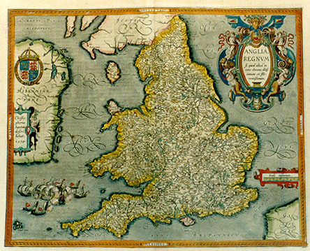
Title: ANGLIA, | REGNVM | "Si quod aliud in | toto Oceano ditis:|simum et flo:|rentissimum". [The kingdom of England, entirely located in the ocean as it is, very rich and flourishing].
(cartouche middle left:) "Christo:|phorus | Saxton | descri:|bebat. | 1579". [[As] Christopher Saxton designed it, 1579.] (cartouche upper left:) HONY SOIT QUI MAL Y PENSE [Shame on whoever thinks badly about it.]
Plate size: 388 x 483 mm
Scale: 1 : 1,150,000
Identification number: Ort 20 (Koeman/Meurer: 143, not in Karrow, van der Krogt AN: 5100:31B)
Occurrence in Theatrum editions and page number:
some 1602S12 or 13 (100 copies printed?),
1603L12 (300 copies printed) (last line, left aligned: in Britannia imperio prć manibus habet.),
few 1608/1612I12 (50 copies printed?),
few 1609/1612S12 (50 copies printed?),
few 1613D11 (25 copies printed?)(last line, centered like 4 lines above it, in Gothic script: onder de jurisdictie van Enghelandt.).
States: 20.1 only.
Approximate total number of copies printed: 425.
Cartographic sources: Christopher Saxton (about 1542-1611) made a series of 35 maps of England and Wales which appeared in 1579 as an atlas. Vrients drew on the England map for this plate (Meurer p. 228-229). A slightly reduced close copy of this map appeared in 1605 under the imprint of Jean Le Clerc (Shirley's map 271). The Saxton map was engraved by Augustus Ryther, a skilled engraver and instrument maker. The engraving profession required not only engraving skills but also familiarity with Greek, since many of the symbols used on instruments were Greek letters. It was not uncommon to shorten the spelling of words at this time, and this happened on the Saxton map where all names ending in -ham were shortened to hm, but with the small Greek letter pi engraved above the m. This was copied both in the Ortelius derivative of this map and on the Le Clerc one. I am grateful to Art Kelly and Peter Barber for their information on this matter.
References: Shirley (1991), p. 104, map 258. A. Kelly "Maps of the British Isles, England and Wales, and Ireland", p. 221-238, in Van den Broecke, van der Krogt & Meurer (eds.) "Abraham Ortelius and the First Atlas, 1998, HES Publishers.
Remarks: this map replaces Ort 19 and is in its turn succeeded by Ort 17. Although the Saxton example was published as early as 1579, Ortelius probably did not include it out of reverence to his deceased friend Llhuyd, or because it did not have many new insights to offer. It was most probably introduced by Vrients.
For questions/comments concerning this page, please e-mail info@orteliusmaps.com.