Cartographica Neerlandica Background for Ortelius Map No. 165
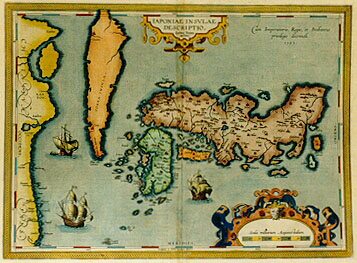
Title: IAPONIAE INSVLAE | DESCRIPTIO. | "Ludoico Teisera | auctore". [A representation of the island of Japan by Luis Teixeira] (Upper right:) "Cum Imperatorio, Regio, et Brabantić | priuilegio decennali. | 1595". [With imerpial, royal and Brabant privilege for ten years. 1595.]
Plate size: 358 x 486 mm.
Scale: 1 : 4,500,000.
Identification number: Ort 165 (Koeman/Meurer: 134, Karrow: 1/198, vdKrogtAN: 8450:31).
Occurrence in Theatrum editions and page number:
1595L5Addblank (100 copies printed) (text and typesetting identical to 1595L, but without page number; last line first text page, full width: puluere Chia:(herbć hoc cuiusdam admodű salutaris nomen)circa eam potionem diligentissimi sunt:ac ; last line second text page, left aligned: sius.aliaque etiam plura,de hac Iaponia.De eadem passim multa in Iesuitarum Epistolis editis.),
1595L107 (500 copies printed) (text and typesetting identical to 1595L5Add, but here with page number 107; last line first text page: puluere Chia:(herbć hoc cuiusdam admodu salutaris nomen)circa eam potionem diligentissimi sunt:ac; last line second text page, left aligned: sius.aliaque etiam plura,de hac Iaponia.De eadem passim multa in Iesuitarum Epistolis editis.),
1597G5Addblank (75 copies printed) (identical to 1602G but without page number; last line, left aligned, in small Gothic script like the entire text: durch starcken wind in der Japoniter Insulen getrieben/im Jahr der weniger zall vierzig zwey.),
1598F108 (525 copies printed) (last line, left aligned: des Peres de la Compagnie de IESVS.),
1598/1610/1613D76 (100 copies printed) (penultimate line first text page, in Gothic script like the entire text: recht verscheyde vogelen met vergulde voeten ende becken.De gast is daer wel onthaelt. Het zijn oock by hen ; last line: veel),
1601L107 (200 copies printed) (last line first text page, right aligned: princi- ; last line second text page, left aligned: lis editis.),
1602S110 (250 copies printed) (last line first text page, right aligned: ellos ; last line second text page, left aligned: imprimidas.),
1602G110 (250 copies printed) (identical to 1597G5Add but with page number 110; last line, left aligned, in small Gothic script: durch starcken wind in der Japoniter Insulen getrieben/im Jahr der weniger zall vierzig zwey.),
1603L110 (300 copies printed) (last line, first text page, right aligned: oryza ; last line, second text page, left aligned: Iesuitarum Epistolis editis.),
1606E107 (300 copies printed) (penultimate line, first text page, full width: and fish : the wealthier sort do set out their banquets richly and with great variety of dishes : at euery messe ech mans trenches | made ; second text page, left aligned: of these Ilands of "Iaponia". Of the same there are heere and there mny thing in the Iesuites Epistles.),
1608/1612I119 (300 copies printed) (last line first text page, right aligned: ramide, ; last line second text page, left aligned: Maffeo di questo Iapone. Dell'istesso qua & la molte altre notitie s'hanno dalle lettere stampate delli Iesuiti.),
1609/1612L120 (300 copies printed) (last line, left aligned, small font: dem passim multa in Iesuitarum Epistolis editis.),
1609/1612/1641S120 (325 copies printed) (last line first text page, right aligned: riosos. ; last line second text page, left aligned: bien mucho d'ella en las epistolas o cartas de los Iesuytas imprimadas.).
Approximate number of copies printed: 3525.
States: 165.1 as described.
165.2: during or after 1612S the date 1595 was removed.
Cartographic sources: Luis Teixeira, a Portuguese cartographer, sent Ortelius in 1592 two maps of China and Japan (Hessels letter 210) which are based on unknown sources (Meurer p. 253-254).
References: "Map Collector Circle" 36:2; Lutz Walter (1994) "Japan, a cartographic vision", Prestel, Munich, p. 41, p. 212 map 5.
Remarks: This map is a milestone in the cartography of Japan, and surprisingly accurate as far as the Japanese islands are concerned. Although as early as 1617 the more accurate map of Japan by Blancus appeared, this map retained influence until more than 50 years later a new milestone map of Japan appeared, viz. the Martini map of 1655.
The part of this map depicting Japan was reproduced on a stamp of 60 Ąen issued by the Japanese government in 1985.
For questions/comments concerning this page, please e-mail info@orteliusmaps.com.