Cartographica Neerlandica Background for Ortelius Map No. 12
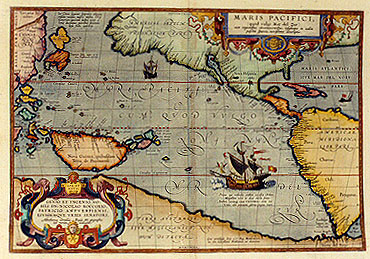
Title: MARIS PACIFICI, | (quod vulgó Mar del Zur) | "cum regionibus circumiacentibus, insulisque in eodem | passim sparsis, novissima descriptio". [A very new description of the peaceful sea, commonly called South Sea with the regions lying around it, and its islands, scattered everywhere]. (bottom right:) "Cum privilegiis Imp. & Reg. Maiestatum, | nec non Cancellarić Brabantić, ad decennium". [with privileges of the imperial and royal Majesties, as well as of the Brabant council, for a period of ten years]. (cartouche lower left:) SPE ET | METV | GENIO ET INGENIO NO:|BILI DN. NICOLAO ROCCOXIO, | PATRICIO ANTVERPIENSI, | EIVSDEMQVE VRBIS SENATORI, | "Abrahamus Ortelius Regić Mts. geographus | sub. merito dedicabat. | 1589". [In hope and reverence, through application and talent, Abraham Ortelius, geographer of his royal Majesty because of merit, has dedicated [this map] in 1589 to the honourable Lord Nicolaus Roccoxius, patrician of Antwerp, and senator of that city]. Text block below ship: "Prima ego velivovis ambivi cursibus Orbem, | Magellane novo te duce ducta freto. | Ambivi, meritoque vocor VICTORIA: sunt mî | Vela, alć; precium, gloria: pugna mare". [I was the first to sail around the world by means of sails, and carried you, Magellan, leader, first through the straits. I sailed around the world, therefore I am justly called Victoria [Victory], my sails were my wings, my prize was glory, my fight was with the sea]. Text block upper left near Japan: "In China regione, Iapania alijsque | insulis vicinis, messis multa Chris:|tianorum: quorum indies novć co:|loniae ducuntur, patribus societatis | Iesu fidis operarijs". [In the region of China, as also of Japan and the neighbouring isles, many have been won for the Christian faith by the fathers of the society of Jesus, going to the settlements in the new Indies, as a result of their efforts]. (Lower left:) Nova Guinea, quibusdam | Terra de Piccinacoli. [New Guinea, according to some the land of the Pinnacoli].
Plate size: 344 x 498 mm
Scale: 1 : 40,000,000
Identification number: Ort 12 (Koeman/Meurer: 124, Karrow: 1/164, vdKrogtAN: 0600:31)
Occurrence in Theatrum editions and page number:
1590L4Addblank (100 copies printed) (identical in text and typesetting to 1592L, but without page number; last line, in small font, left aligned: habitantes mutuň accepisse, non video quis testagari posset.),
1591G4Addblank (75 copies printed) (last line, centred like 4 lines above it, in Gothic script: underscheydt erkennen.),
1592L6 (525 copies printed) (text and typesetting identical to 1590L4Add, but here with page number 6; last line, small font, left aligned: habitantes mutuň accepisse, non video quis testagari posset.),
1595L6 500 copies printed) (last line, small font, left aligned: norum ante multa fortč sćcula prćoccupasse. vt qui multň Indis propriores,neque vt tabulć ostendunt,tam vasto Oceano ab hac vt Indi,discretos.),
1598/1610/1613D6 (100 copies printed) (last line, first text page, right aligned, in Gothic script: Aen dese),
1598F6 (525 copies printed) (last line, left aligned, very small font: peut voir aux tables icy mises.),
1601L6 (200 copies printed) (last line, left aligned: ex Limano portu Peruuiano soluens,per hunc immensum Oceanum nauigasset:apud Iosephum ŕ Costa,lib.1.cap.17.de Natura Noui Orbis.),
1602G6 (250 copies printed) (last line, centred like 4 lines above it, in Gothic script like the entire text: underscheyde erkennen.),
1602S6 (250 copies printed) (last line, left aligned: nauegado por este gran Mar d'el Zur.),
1603L6 (300 copies printed) (this text and page number are identical to 1609/1612S/L, but the typesetting is different; page number 6 positioned under the word Natura; last line, left aligned: classe ex Limano portu Peruuiano soluens, per hunc immensum Oceanum nauigasset : apud Iosephum ŕ Costa, lib. 1. cap. 17. de Natura Noui Orbis.),
1606E6 (300 copies printed) (last line, full width: his fleet out of the part of "Lima" in "Peru",& had sailed ouer this huge Ocean : as I find recorded in "Iosephus Acosta" his 1.book & 17.chapter "De natura noui orbis".),
1608/1612I6 (300 copies printed) (last line, left aligned: nuouo Mondo.),
1609/1612/1641S12 (325 copies printed) (last line, left aligned: de Peru,auiendo pasado y nauegado por este gran Mar d'el Zur.),
1609/1612L6 (300 copies printed(this text and page number are identical to 1603L, but the typesetting is not; page number 6 positioned under the word lib; last line, full width: classe ex Limano portu Peruuiano soluens,per hunc immensum Oceanum nauigasset: apud Iosephum ŕ Costa, lib. 1.cap. 17.de Natura Noui Orbis.).
Approximate total number of copies printed: 4050
States: 12.1 as above;
12.2: after 1612, date removed.
Cartographic sources: this map is based on Mercator's world map which appeared in 1569, with details from some 25 Portuguese manuscript maps of Bartolomeo de Lasso which Plancius possessed and later used for his own world map (Meurer p. 36, 216).
Remarks: Quite a few of the new place names appearing along the North American west coast were provided to Ortelius by Hakluyt on the basis of recent explorations, which were not published for political reasons. This first printed map of the Pacific is of fundamental cartographical importance.
References: T. Suarez (1983) Early Mapping of the Pacific Ocean, The Map Collector 22: pp. 2-9.
For questions/comments concerning this page, please e-mail info@orteliusmaps.com.