Cartographica Neerlandica Background for Ortelius Map No. 118
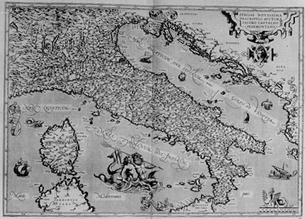
Title: ITALIAE NOVISSIMA | DESCRIPTIO AVCTORE | IACOBO CASTALDO | PEDEMONTANO. [A very new representation of Italy by Jacobus Castaldi of Piemont].
Plate size: 355 x 497 mm
Scale: 1 : 3,000,000
Identification number: Ort 118 (Koeman/Meurer: 112, Karrow: 1/43a, vdKrogtAN: 7000:31B).
Occurrence in Theatrum editions and page number:
1584L64 (750 copies printed) (last line, left aligned, in cursive script: "liam Cisalpinam,quæ non minimam Italiæ partem comprehendit,Gaudentius Merula pulcherrimè descripsit".),
1587F64 (250 copies printed) (last line, left aligned, in cursive script like the entire text: "a fait une description tresdiligente."),
some 1588S64 (100 copies printed) (last line, left aligned: esta muy lindamente declarada por Gaudentio Merula.),
1592L68 (525 copies printed) (last line, left aligned, in cursive script like 4 lines above it: "dentius Merula pulcherrimè descripsit".),
1595L71 (500 copies printed) (12th line from the top contains: M.C.LXVI ; last line, left aligned, italic: "Gaudentius Merula pulcherrimè descripsit".),
1598F73 (525 copies printed) (last line, in italic script like the entire text, left aligned: "scription tresdiligente."),
1598/1610/1613D53 (100 copies printed) (last line, centred like 3 lines above it: ter neerstichheyt beschreuen heeft.),
1601L71 (200 copies printed) (12th line from the top contains M.C.XCVII. ; last line, left aligned, in italic script like four lines above it: "Gaudentius Merula pulcherrimè descripsit".),
1602G74 or none (250 copies printed) (last line, centred like 6 lines above it, in Gothic script like the entire text: schriben.),
1602S74 (250 copies printed) (last line, left aligned: que comprehende gran parte de Italia,està muy lindamente declarada por Gaudentio Merula.),
1603L74 (300 copies printed) (last line, left aligned, in cursive script: "Gaudentius Merula pulcherrimè descripsit".),
1606E71 (300 copies printed) (last line, full width: "Leander,Gaudentius Merula" hath most excellently described "Gallia Cisalpina", which indeed is not the least part of "Italie".),
1608/1612I79 (300 copies printed) (last line, left aligned, in cursive script like 4 lines above it: "bardia,la qual non è la minima parte dell'Italia , con le circonstanti contrade ,alla detta Gallia pertinenti."),
1609/1612L78 (300 copies printed) (last line, left aligned, in cursive script like four lines above it: "rula pulcherrimè descripsit".),
1609/1612/1641S78 (325 copies printed) (last line, left aligned: lia, esta muy lindamente declarada por Gaudentio Merula.).
States: 118.1 only.
Note that a not-so-close copy of this map can be found in the National Library of Naples (Italy), bound in an Italy atlas by Magini. On this map the date 1619 can be found in the cartouche, and below the Neptune pair we find the text: Godifredus de Scaichi Ultraiectinensis exc. 1619. To the right of the pair, an elaborate compass rose, mostly featuring exotic proper names has been added.
Approximate number of copies printed: 5150.
Cartographic sources: Giacomo Gastaldi (abt. 1500-1566) (Karrow 30/90, p. 216-249, Meurer p. 148-154), whose map of Italy was published in Venice in 1543. Other Italy maps mentioned in the "Catalogus Auctorum" are those by Bordone and Ioannes Andreas Valvasorius, presumably from 1516.
Remarks: Replaces plate Ort 117 from 1584L onwards. However, we found a copy of the early plate Ort 117 belonging to an edition as late as the 1609/1612S one. The early plate Ort 117 has "SERVIA" in the upper right corner, this late plate does not.
For questions/comments concerning this page, please e-mail info@orteliusmaps.com.