Cartographica Neerlandica Background for Ortelius Map No. 69
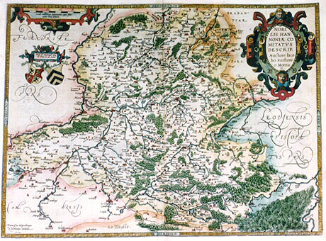
Title: NOBI:|LIS HAN:|NONIĆ CO:|MITATVS | DESCRIP. | Auctore Iaco|bo Surhoni:|o Monta:|no. [A representation of the countship of noble Hannonia by Iacobus Surhonius Montanus]. (Bottom left:) "Franciscus Hogenbergus | ex archetypo cślabat. | 1572." [Engraved by Franciscus Hogenberg after the original 1572]. Upper left: "Pays de Haynault tenu | de Dieu et du soleil". [The land of Haynault, held by God and the sun].
Plate size: 374 x 506 mm
Scale: 1 : 200,000
Identification number: Ort 69 (not recorded by Koeman or Karrow, van der Krogt AN: 3320:31A)
Occurrence in Theatrum editions and page number:
1584L36 (last line, centred like 4 lines above it: lulo non contemnenda de hac recenset.),
1595L40 (last line, full width: Leodius quoque,in suo de Tungris & Eburonibus libellulo, non contemnenda de hac recenset.),
1603 (Vrients1) has no text or page number.
States: 69.1 (a proof state?) is a state of which only one copy is known. It does not have the date 1572.
69.2 the date 1572 was added in 1584. In the 1584 Latin edition, the page number 36 is heavier than the rest of the typesetting.
Approximate number of copies printed: perhaps about 300, maybe more.
It cannot be assumed that all 1584 Latin and 1595 Latin copies contain this map (the University library Amsterdam has Ort71 instead and the 1595L edition normally contains Ort 70 or Ort71}.
Cartographic sources: Jacques and Jean Surhon 1548.
References: Meurer (1994) "De verboden eerste uitgave van de Henegouwen-kaart door Jacques Surhon uit het jaar 1572" [the censored first issue of the Hainault-map by Jacques Surhon, dated 1572], Caert-Thresoor 13(3) p. 81-87, on which most of the above information is based. However, this map is not as rare as Meurer suggests. See also H.A.M. van der Heijden "Ortelius and the Netherlands", p. 271-290 in: M. van den Broecke, P. van der Krogt and P. Meurer (eds.) "Abraham Ortelius and the First Atlas", HES Publishers, 1998.
Remarks: See further plates Ort 70 and Ort 71.
Privilege for this map was requested by Ortelius in 1572, but not obtained. The engraving of copperplate was paid for by the authorities, but it was to be destroyed. This did not apply to the prints that had been made from it, which were clearly used.
For questions/comments concerning this page, please e-mail info@orteliusmaps.com.