Cartographica Neerlandica Background for Ortelius Map No. 163
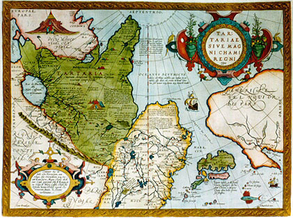
Title: TAR:|TARIAE | SIVE MAG|NI CHAMI | REGNI | "typus". [Map of Tartaria or the kingdom of the great Cham]. (Bottom left corner:) "Cum Priuilegio". [With privilege] (Textblocks, from top to bottom, from left to right:) "NepthalitarŻ | horda Nepthalitś ab una 10. Tribuum Israelis nomine | Neptali dicti sunt et post Dani:|tas qui in qui in castigatione Aquilona:|ri Danmarchi dicti sunt, ob Rache|lis Balbah ius secundo in loco Hu|dorŻ sive Iehudeorum sunt positi | et 476 sal anno contra Perosa | victores fuere, Euthalitas male | vocant ceteri". [The Nephalites are named Neptali after one of the 10 tribes with a Hebrew name, and after the Danites, who by way of punishment were called the Danes of the dark North, and they were on account of the claims of Rachel Balbah placed to the side, in the area of the Hudores or Iehudeores; in the year 476 they were victorious in their battle against Perosa. Others call them incorrectly Euthalites. (Next textblock:) "OCEANVS SCYTHICVS| dulcis est Plinio auctore, qui multas in eo | insulas eŖe dicit, vt etiam M. Paul: Vene:|tus: sed neuter neque situm neque numerŻ tradit". [The Scythian ocean, according to Plinius, has sweet water, and he also says it contains many islands, as M. Paulus [Marco Polo] also says, but neither of the two tells about their number or location]. (Next texblock:) "Tabor seu Tybur vmbilicariaue Tota:|rorum regio, vbi licet olim libros sacros | perdidiŖent, sunt tamen vniti sub uno | rege, qui 1540. in Galliam vsque ad regem | Franciscum id nominis primum venit, et | postea a Carolo V. Mantuś ignś sue infide:|litatis poenas luit: quia secrete solicitabat | Christianos principes ad Iudaismum, de | qua re Carolum V. alloquutus erat". [Tabor or Tybur, centre of the area of the Tartars, where once the Holy Books got lost, yet they are united under one king, who in 1540 first reached France and king Franciscus, and later, at the initiative of Charles the Fifth was burnt at the stake for his heresy, because he had secretly endeavoured to convert Christian kings to the Jewish religion, about which he had spoken with Charles the Fifth.] (Next textblock:) "4 Esd. v.13, ARSARETH. | Hic 10. tribus seceŖere et TotatorŻ siue Tar:|tatorum loco Scythicś substituerunt. Vnde Gauthś | seu Gauthay ŗ summa Dei gloria aŖerenda ibi | dicti sunt, et hinc Cathay clariŖ: Regnum". [4 Ezdra 13; Arsareth. Here the ten tribes retreated, and changed from the Tatar or Tartar area to Scythia. Since then they are called Gauths or Gauthens, confirming Gods highest glory, and here lies the splendid kingdom of Cathai.] (Next textblock:) "TVRCHESTAN Regio | vnde cismontani 10. Tribuum socij ante | 900 aŮos sunt accersiti ŗ Persis contra Isma:|elitś Mahumedis arma". [Turkestan. The area from which the 10 tribes as allies living on this side of the mountain range have been called 900 years ago by the Persians to fight the armies of Ismael the Muslim.] (Next block:) "Magnus Cham, (quod | linga Tartarorum Im:|perator sonat) max:|imus Asiś princeps". [The great Khan (which in the language of the Tatars means emperor), the highest ruler of Asia.] (Next block:) "ARGON. Christianorum olim | regnŻ noie Presbiteri Iois in Asia erat, | ŗ D. Thoma ibi institutum, vt Roma:|nś corresponderet ecclesiś, per Presbi:|terum IoÍm Africanum Romś obediens | Et antequ„ a Gothanis vinceretur | Criue Romoue nuncupabantur". [Argon. Once there was in Asia a Christian kingdom, known to Prester John, and D. Thomas founded it [this city] in this place, so that it was in contact with the church of Rome, and was subjected to Rome through Prester John of Africa. Before it was defeated by the Goths, it was known as Crive Romove.] (Cartouche at left bottom:) Continet hśc ta:|bula oÍm Tartariam, cum | reliqua Asiś Orientalioris usque Oce:|anŻ Eoum parte, Magno Chamo obedi:|ente: Cuius imperium Obij fl: Kataia la:|cu: Volga fl: Mari Caspio, Chesel flu: | Usonte monte, Thebet regione, Ca:|romoram fluuio, & Oceano | terminatur". [This map contains the area of Tartaria, with the remaining part of East Asia to the Morning Ocean, subject to the great Khan whose might is bounded by the river Ob, Lake Kataia, the Volga, the Caspian Sea, the river Chesel, the mountains of Usson, the area of Tibet, the river Caromora and the Ocean.] (5 lines in the ocean near Japan:) "Japan insula, ŗ M. Paulo | Veneto Zipangri dicta, | olim Chrˇse, a Magno | Cham olim bello petita | sed frustra". [The isle of Japan, called Zipangri by Marco Polo of Venice, formerly [called] Chrˇse, once attacked by the great Khan in war, but without success.] (Left top:) "Hic magnus prouentus | calami aromatici". [Here you find great quantities of aromatic reeds.] (Left side middle:) "Hic Rubini | gemmś re:|periuntur". [Here ruby stones are found.] (Centre:) "TANGVT. Hic artÍ | imprimendi ante mille vt | ferunt, annos habuerunt". [TANGVT. Here the art of printing was invented thousand years ago, as they say.] (Centre:) "Mons Althaˇ, vbi oÍs Tartariś | imperatores sepeliuntur, ab Haˇ:|tone Armeno sub noÓe Belgi:|an describi videtur". [Mount Althay, where all emperors of Tartaria are buried, seems to have been described by Haithon the Armenian under the name of Belgian.] (Centre left:) TARTARIA, "Quś Sar:|matiam, Asiaticam, & vtramque Scythiam | veterum comprśhendit". [Tartaria which comprises Asian Sarmatia and Outer Scythia of the ancients.] (Top centre:) "Schyticum | prom:" | Danorum | "siue Danitarum | horda 1. deiectio siue | descensio aut expulsio". [Scythian promontory of the Dani or Daniti, a tribe which has disappeared because it has been expelled or has left.] (Centre top:) "Insula falco:|num, M Paul: | Veneti". [The isle of the falcons, according to Paulus Venetus.] (Centre:) "Cambalu Cataiś | metropolis, habet | 28.mill: in | circuitu". [Cambalu, the metropolis of Cathay, is 28 miles in circumference.] (Bottom centre:) "His montibus eru:|untur lapides, quib: | utuntur ad focum | loco lignorum". [From these mountains stones are thrown up which are used as a fire instead of wood.] (Right centre:) "Quinsai id est | ciuitas celi". [Quinsai means community of heaven.]
Plate size: 349 x 470 mm
Scale: 1 : 20,000,000
Identification number: Ort 163 (Koeman/Meurer: 47, Karrow: 1/67, vdKrogtAN: 8050:31)
Occurrence in Theatrum editions and page number:
1570L(AC)47 (225 copies printed) (penultimate line begins: genda ; last line, centred like 6 lines above it: libro.18.cap.30.),
1570L(B)47 (100 copies printed) (penultimate line begins: gligenda; last line, centred like 5 lines above it: libro.18.cap.30.),
1571L47 (275 copies printed) (penultimate line begins: gligenda; last line, centred like 5 lines above it: libro.18.cap.30.); another version, last line centred like 2 lines above it: multa; vt & Gregoras alius scriptor Grścus.),
1571/1573D47 (350 copies printed) (last line, centred like 2 lines above it: haere sprake Besermanni,als Sigismundis van Herbersteyn schrijft.),
1572G47Koler (pasted over p.47 in a 1570L edition; few copies printed)(last line, left aligned, mostly in Gothic script: rasenischen histori/und den Brief Iacobi Nouarchi des Iesuiten,Es ist von den Tartarn auch etwas beym Nicephero, so nicht zuverachten /in seinem 30.Cap. des 18. Buchs.),
1572/1573G47 (225 copies printed) (last line, centred like 5 lines above it: schreibt) Besermanni.),
1572/1574F47 (225 copies printed) (last line, centred like 2 lines above it: eux mesmes en langue Tartarique,Besermani,comme escrit Sig,d'Herbersteyn.),
1573L(A)62 (40 copies printed) (end of first text line from the top: necesse ; last line, centred like 3 lines above it: Gregoras alius scriptor Grścus),
1573L(B)62 (40 copies printed) (end of first text line from the top: easdem ; last line, centred like 4 lines above it: Gregoras alius scriptor Grścus.),
1574L62 (175 copies printed) (large page number, 11 mm; last line "Gregorasalis", another variant: last line, centred like 4 lines above it: Gregoras alius scriptor Grścus),
1575L62 (100 copies printed) (small page number, 7 mm; last line, centred like 3 lines above it: locis multa, vt & Gregoras alius scriptor Grścus.),
1579L(A)83 (250 copies printed) (last line, left aligned: Scytharum nomine variis in locis multa, vt&Gregoras alius scriptor Grścus. ; page number 83 positioned below Tartaris of penultimate text line.),
1579L(B)83 (250 copies printed) (last line, left aligned: Scytharum nomine variis in locis multa, vt & Gregoras alius scriptor Grścus. ; page number 83 positioned below Grścus of last text line.),
1580/1589G83 (350 copies printed) (last line, centred like 5 lines above it, in Gothic script: scher Scribent.),
1581F83 (400 copies printed) (last line, left aligned: lent eux mesmes en langue Tartarique,Besermani,comme escrit Sig.d'Herbersteyn.),
1584L92 (750 copies printed) (last line, left aligned: Scytharum nomine variis in locis multa,vt & Gregoras alius scriptor Grścus.),
1587F92 (250 copies printed) (last line, left aligned: eux mesmes en langue Tartarique , Besermani , comme escrit Seig.d'Herbersteyn.),
1588S92 (300 copies printed) (last line, left aligned: res debaxo d'el nombre de Scythas,como tambien Gregoras, otro escritor Griego.),
1592L100 (525 copies printed) (last line, left aligned: multa,vt & Gregoras alius scriptor Grścus.),
1595L105 (500 copies printed) (last line, left aligned: in Saxoniś Chronico.),
1598F106 (525 copies printed) (last line, left aligned: eux mesmes en langue Tartarique, Besermani,comme escrit Seig.d'Herbersteyn.),
1598/1610/1613D74 (100 copies printed) (last line, left aligned: als Sigismundus van Herbersteyn schrijft.),
1601L105 (200 copies printed) (last line, left aligned: ius itinerarium his partibus,anni 1253.extat apud me M.S.),
1602G108 (250 copies printed) (last line, centred like 5 lines above it, in Gothic script like the entire text: scher Scribent.),
1602S108 (250 copies printed) (last line, left aligned: Itinerario de estas partes , del aŮo 1253. cerca de mi esta M.S.),
1603L108 (300 copies printed) (text, but not page number and typesetting, identical to 1609/1612L; last line, left aligned: rarium his partibus, anni 1253.extat apud me M.S.),
1606E105 (300 copies printed) (last line, left aligned: haue by me in written hand.),
1608/1612I117 (300 copies printed) (last line, left aligned: parti l'anno 1253. scritto ŗ mane io tengo.),
1609/1612L118 (300 copies printed) (text, but not page number and typesetting, identical to 1603L; last line, left aligned: rarium his partibus, anni 1253.extat apud me M.S.),
1609/1612/1641S118 (325 copies printed) (last line, left aligned: d'el aŮo 1253. cerca de mi esta M. S.).
Approximate number of copies printed: 8175.
States: 163.1 as described.
163.2: from 1573L version B onwards, hatching of the coast lines was extended from 2-3 mm to 5-6 mm. The ship in the centre receives portholes. The horizontal hatching of the semicircular ornament of the title cartouche was extended downwards by 3 mm. The part just above it with two upward curling flaps now has cross-hatching where it used to have horizontal hatching only. The birds at the extreme left and right are now fully feathered. The right side of the cartouche bottom right now has cross-hatching all over, where it used to have mostly vertical hatching. In the course of time, this new cross-hatching fades away, and by 1609, the original state has returned.
163.3: from 1587F onwards, all coast lines, islands etc. received another round of additional horizontal hachuring. Where the original hachuring was 2-3 mm, and the intermediate phase had to 5-6 mm, it is now 7-9 mm. The ship in the centre of the map now has waves under it extending all along below the ship.
163.4: in 1609, the ship in the centre was re-engraved, and the portholes disappeared again.
From 1595 onwards, the lower left corner started to break off. By 1609, the missing piece measures 4 x 6 mm, and the stippling of the sea has completely faded away.
Cartographic sources: Ortelius' 1564 wall map of the world and his 1567 wall map of Asia, both in 8 sheets. His Asia map in turn was based on Gastaldi 1561 (Karrow p. 2-3, Meurer p. 38), and the Western part possibly on Herberstein, as Brandmair argues.
Remarks: this is one of the first maps showing the Anian (Bering) straits.
For questions/comments concerning this page, please e-mail info@orteliusmaps.com.