Cartographica Neerlandica Background for Ortelius Map No. 84
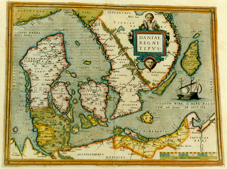
Title: DANIAE | REGNI | TYPVS [Image of the Kingdom of Denmark]. (Lower left:) "Cum | Priuilegio." [With privilege].
Plate size: 315 x 415 mm
Scale: 1 : 2,250,000
Identification number: Ort 84 (Koeman/Meurer: 21, Karrow: 1/29, van der Krogt AN: 1500:31A).
Occurrence in Theatrum editions and page number:
1570L(AC)21 (100 copies printed) (full stop after title; last line, centred like 8 lines above it: Iacobus Zieglerus),
1570L(B)21 (125 copies printed)(full stop after title; last line, centred like 8 lines above it: Olaus Magnus , & Iacobus Zieglerus),
1571L21 (275 copies printed) (last line, centred like two lines above it: Olaus Magnus,& Iacobus Zieglerus.),
1571/1573D21 (350 copies printed) (last line, in italic script like the entire text, centred like two lines above it: "aen sien kan watse eertijts gheweest is."),
1572/1574F21 (225 copies printed) (last line, centred like 2 lines above it: qui demonstrent assez ce, qu'elle a esté iadis.),
1572G21Koler (pasted over p.21 of a 1570L edition; few copies printed) (last line, left aligned, in Gothic script except for two names: dens/befandt/in welchem ein Liberey von 2000. Autorum und alten Büchern ist. Sovil melden Olaus Magnus und Iacobus Ziglerus.),
1572/1573G21 (225 copies printed) (last line, cursive like the entire text, centred like 3 lines above it: "sehen kan was sie vorzeitten gewest ist".),
1573L(A)25 (40 copies printed) (last line, centred like 2 lines above it: veterum. hćc Olaus Magnus,& Iacobus Zieglerus.),
1573L(B)25 (40 copies printed) (last line, centred like 2 lines above it: veterum . hćc Olaus Magnus,& Iacobus Zieglerus.),
1574L25 (175 copies printed) (entire text in non-cursive script; large page number, 11 mm, last line, centred like 3 lines above it: terum.hćc Olaus Magnus,& Iacobus Zieglerus.),
1575L25 (100 copies printed) (entire text in cursive script; small page number, 7 mm; last line, centred like 3 lines above it: "terum.hćc Olaus Magnus,& Jacobus Zieglerus".),
1579L(A)38 (250 copies printed) (last line: auctorum & codicű veterum . hćc Olaus Magnus, & Iacobus Zieglerus.)
1579L(B)38 (250 copies printed) (last line: auctorum&codicum veterum. hćc Olaus Magnus,& Iacobus Zieglerus.)
1580/1589G38 or 39 (350 copies printed) (last line, centred like 5 lines above it, in Gothic script: Zieglerus dauon.),
1581F38 (400 copies printed) (last line, left aligned: nez,qui demonstrent assez ce qu'elle a esté iadis.).
Approximate total number of copies printed: 3000
States: we know 84.1 only.
Cartographic sources: central part of Cornelis Anthoniszoon 1499-1557 Caerte van Oostland, Germany-map of Sgroot, Scandinavia map of Olaus Magnus and possibly Marcus Jordanus' 1552 map of Denmark (Karrow 6/8, p. 44-45, Meurer p. 104-105). In the 1572 German edition we find in the text of this map (in translation): "To this Kingdom of Denmark also belongs Norway, and (as Marcus Jordanus mentions on his map printed in Copenhagen) the islands of Gotland, Greenland, Iceland, Faroer, Hetland and the Orcades".
Remarks: Replaced by map Ort 85a, which is a half sheet map of Denmark.
For questions/comments concerning this page, please e-mail info@orteliusmaps.com.