Cartographica Neerlandica Background for Ortelius Map No. 71
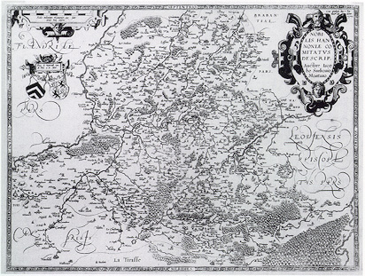
Title: NOBI:|LIS HAN:|NONIĆ CO:|MITATVS | DESCRIP. | "Auctore Iaco:|bo Surhonio | Montano". [A depiction of the noble duchy of Hannonia, by the author Iacobus Surhonius Montanus], (Top right:) "Cum Privilegijs Imp. et Reg. | Maitis ad decenn. | 1579" [With imperial and royal privilege for ten years. 1579]. (Cartouche upper left:) "Pays de Haynault | tenu de Dieu et du Soleil". [Land of Hannonia, enlightened by the Lord and the Sun].
Plate size: 369 x 485 mm
Scale: 1 : 200,000
Identification number: Ort 71 (Koeman/Meurer: 111, Karrow: 1/116a, van der Krogt AN: 3320:31C)
Occurrence in Theatrum editions and page number:
1579/1580L2Add20b (200 copies printed) (last line, centred like 3 lines above it, libellulo non contemnenda de hac recenset. 5th line from the bottom ends: va-),
1579L(A)30 (200 copies printed) (last line, centred like 3 lines above it: libellulo non contemnenda de hac recenset. ; 5th line from the bottom ends: va-),
1579L(B)30 (200 copies printed) (last line, centred like 3 lines above it: libellulo non contemnenda de hac recenset. ; 5th line from the bottom ends: vitreorum),
1580G2Add20b (50 copies printed) (last line, centred like 6 lines above it, in Gothic script like the entire text: ronern.),
1580/1589G30 (350 copies printed) (last line, centred like 6 lines above it, in Gothic script like the entire text: ronern.),
About half of 1584L36 (375 copies printed) (last line, centred like 4 lines above it: lulo non contemnanda de hac recenset.),
Few 1592L38 (50 copies printed?)(no data available.),
Some 1595L40 (200 copies printed?) (last line, left aligned: Leodius quoque,in suo de Tungris&Eburonibus libellulo,non contemnenda de hac recenset.),
Few 1602S42 (50 copies printed?) (last line, left aligned: sta prouincia.),
Some 1602G43 (100 copies printed?) (last line, centred like 6 lines above it, in Gothic script like the entire text: ronern.),
Few 1606E40 (50 copies printed?) last line, left aligned: things.),
Few 1609/1612L47 (50 copies printed?} (last line, left aligned: gris & Eburonibus libellulo , non contemnenda de hac recenset.).
Very approximate number of copies printed: 1875.
States: 71.1 as described.
Cartographic sources: Jacques Surhon made a manuscript map of Hannonia as early as 1548. For security reasons it was not published. Only in 1579, when Antwerpen was independent for a short time, did Ortelius use it. (Meurer p. 250-251).
References: H.A.M. van der Heijden "Ortelius and the Netherlands", p. 271-290 in: M. van den Broecke, P. van der Krogt and P. Meurer (eds.) "Abraham Ortelius and the First Atlas", HES Publishers, 1998.
Remarks: note that the four wind directions are part of the frame, whereas they are inside the frame in the previous version, Ort70.
For questions/comments concerning this page, please e-mail info@orteliusmaps.com.