Cartographica Neerlandica Background for Ortelius Map No. 231
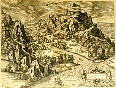
Title: TEMPE. (Cartouche lower right:) "Est nemus Æmoniæ prærupta quod undiq3 claudit | Silva, vocant Tempe, per quæ Peneus ab imo | Effusus Pindo, spumosis volvitur undis. | Ovid. i. Metamorph". (line 568-570): [Here are the inaccessible forests of Æmonia which is everywhere enclosed by a forest called Tempe, through which the river Peneus, scattered by the Pindus Mountain range, tosses with foamy waves]. (Bottom left:) "Delineatum et editum auctore Ab. Ortelio | cum priuilegio decennali 1590". [Designed and published by Abraham Ortelius with a ten year privilege. 1590].
Plate size: 364 x 476 mm.
Scale: not applicable.
Identification number: Ort 231 (Koeman/Meurer: 24P, Karrow: 1/185, van der Krogt AN: P-Tempe:31).
Occurrence in Theatrum editions and page number:
1590L4Addblank ((100 copies printed) (identical in text and typesetting to 1592L, but without a page number; last line, left aligned: (si cui hoc scire quoque libido est) in Cyrrhestica Syriæ regione,inter Berrhœam & Hierapolim.),
1591G4Addblank (75 copies printed) (last line, left aligned, in Gothic script: Gottesdiensts unverletzt:),
1592L26 (525 copies printed) (identical in text and typesetting to 1590L4Add, but here with page number 26; last line, left aligned: (si cui scire quoque libido est) in Cyrrhestica Syriæ regione,inter Berrhœam & Hierapolim.),
1595Lh (500 copies printed) (last line, left aligned: sequente.),
1598/1610/1613D90 (100 copies printed) (last line, in Gothic script like the entire text, centred like 4 lines above it: volcht hier nae.),
1601Lxxxvj (last line, left aligned: minùs esse quàm Tempe amœnum,ad illud quoque delineandum & describendum accedamus. at pagina proximè sequente.),
1602G32 (250 copies printed) (last line, left aligned, in Gothic script like the entire text: unverletzt.),
1603L few xxxvj or usually xxxviij (300 copies printed) (text and page number, but not typesetting, identical with the editions 1609/1612S/L; page number xxxviij positioned below the text words Tempe amœnum ; last line, left aligned: que delineandum & describendum accedamus. at pagina proximè sequente.),
1606Exxxvj (300 copies printed) (last line, first of two text pages, full width: consecrated with great honour & religious seruices. These things and many other hath "Aelianus" written of these "Tempe". | Of),
1608/1612Ixxxviij (300 copies printed) (last line, left aligned, in cursive script like 6 lines above it, very small font: "ghi d'esso eccelsi."),
1609/1612Sxxxviij (text in Latin) = 1609/1612Lxxxviij (600 copies printed) (text and page number, but not typesetting, identical with 1603L; page number xxxviij positioned below the text words esse quàm ; last line, left aligned: que delineandum& describendum accedamus. at pagina proximè sequente.),
1624ParergonL/1641Sxlvij (1025 copies printed) (last line second column first text page, right aligned: nit: ; last line second column second text page, left aligned: quenti.).
Approximate number of copies printed: 4075.
States: 231.1 as described.
231.2 the sun rays which used to be stippled lines, have from 1601 onwards become uninterrupted lines. The horizontal lines in the sky have become denser, particularly around Jupiter's altar. Most trees have also been re-engraved to become more life-like, and also darker.
Cartographic sources: made by Ortelius on the basis of information from ancient sources, specifically Ovidius, Athenæus, Plinius, Herodotus and above all Ælianus and Varro. Herodotus assumes that this valley was the result of an earthquake, though in fact it was caused by erosion. Varro is the source for Ortelius' remark that sacrifices on Jupiter's altar are not blown away. There is no example of an earlier picture of Tempe as a source, which confirms Ortelius' remark in the lower left corner that he drew this design himself, perhaps inspired by mountainous views drawn by Pieter Brueghel the Elder.
References: P.H. Meurer "Ortelius as the Father of Historical Cartography", p. 133-159 in: M. van den Broecke, P. van der Krogt and P.H. Meurer (eds.) "Abraham Ortelius and the First Atlas", HES Publishers, 1998.
Remarks: this is the depiction of the paradise of Tempe in Thessalia, at the foot of mount Olympos. It contains a mixture of Greek myth and history, "where people dwell, meet in companies, and having done divine service and ceremonies in due form and manner, they banquet and make merry", as Ortelius puts it.
For questions/comments concerning this page, please e-mail info@orteliusmaps.com.