Cartographica Neerlandica Background for Ortelius Map No. 210
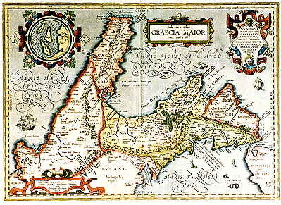
Title: "Itala nam tellus" | GRAECIA MAIOR | "erat. Ovid. 4 Fast." [Italy, which was once Greater Greece. Ovidius Book 4 "Fastorum"]. (Cartouche bottom left:) "Hanc Italić partem exteriorem sic de:|scribere conabar Abrahamus Ortelius. | cum | Priuilegio decennali, | 1595". [This exterior part of Italy is thus depicted in the records of Abraham Ortelius with a privilege for ten years, 1595]. (Cartouche top right:) CL.V.DNO | D. IOACHIMO | CAMERARIO | R.P. NVRENBERG | MEDICO CELEBER:|RIMO, VERO ET VE:|TERI SVO AMICO, | ABRAHAMVS | ORTELIVS | DEDICAB. [Abraham Ortelius has dedicated this map to the most famous lordship Mr. Ioachim Camerarius of Nurnberg, most celebrated physician, as his true and old friend.] (Inset, 70 mm diameter, round:) Diomedeć | insulć. [The Diomedes islands]. (Lower left:) "Salapia, | Annibalis me:|ritricio amore |inclytum". [Salapia, well known because of Hannibal's love for a whore].
(Lower left:) "Aufidus flu. qua solis inter omnes | Italić fluvios Apenninum dividit: | teste Polybio". [The river Aufidus, the only river of all Italy, according to Polybius, that divides the Apennine mountain range].
Plate size: 343 x 476 mm.
Scale: 1 : 1,600,000
Identification number: Ort 210 (Koeman/Meurer: 29P, Karrow: 1/204, van der Krogt AN: 7400H:31).
Occurrence in Theatrum editions and page number:
1595L5Addblank (100 copies printed) (text and typesetting identical to 1595L, but without page number; last line, left aligned: stantissimos nutrire equos.),
1595LO (500 copies printed) (text and typesetting identical to 1595L5Add but here with page number O; last line, left aligned: stantissimos nutrire equos.),
1597G5Addblank (75 copies printed) (identical with 1602G, but without a page number; last line, left aligned, mostly in Gothic script: dey gnant "S. Maria de Trimiti". Diese Insul/wie "Leander" schreibt/soll auch treffliche pferde zeugen.),
1601Lxxij (200 copies printed) (last line, left aligned: Leander Alb.tradit has insulas prćstantissimos nutrire equos.),
1602G20 (250 copies printed) (identical to 1597G5Add, but with page number; last line, left aligned, mostly in Gothic script: dey gnant "S. Maria de Trimiti". Diese Insul/wie "Leander" schreibt/soll auch treffliche pferde zeugen.),
1603L few xxij, most xxiiij (300 copies printed) (text and page number, but not typesetting, identical with editions 1609/1612S/L; last line, left aligned: celebres.Leander Alb. tradit has insulas prćstantissimos nutrire equos.),
1606Exxij (300 copies printed) (last line, first text page, full width: "tia)" which "Dioscorides" in the ninety and eight chapter of his first booke "De medica materia", speaketh of : and which "Pliny", in the | seuenth),
1608/1612Ixxiiij (300 copies printed) (last line, left aligned, in cursive script: "uerendi & celebri molto. Frate Leandro Alberti dice queste isole nutricare excellentißimi caualli".),
1609/1612Sxxiiij (text in Latin) = 1609/1612Lxxiiij (600 copies printed) (text and page number, but not typesetting, identical to 1603L; last line, left aligned: que percelebres. Leander Alb. tradit has insulas prćstantissimos nutrire equos.),
1624ParergonL/1641Sxxviij (1025 copies printed) (last line second column first text page, right aligned: ctus ; last line second column second text page, left aligned: equos.).
Approximate number of copies printed: 3650.
States: 210.1 as described;
210.2: after 1595 and before 1601 "Oenotrides insulć, | quć Pontia et Iscia" was added at bottom centre, and "Diomedis | campus" was added bottom left.
Note that the upper right and lower left corner broke off gradually. Upper left misses about 10 x 12 mm in 1612, and 10 x 20 mm in 1624. Lower left misses 3 x 3 mm in 1612, 5 x 18 mm in 1624 and 5 x 24 in 1641.
Cartographic sources: numerous classical authors, specifically Trogus, Plinius, Festus, Servius, Vergilius, Seneca and Strabo.
Remarks: the inset, I. di Tremite [Islands of Tremite] (actually located just outside the lower left corner of the map), belonged to the kingdom of Naples, and are described as the Diomedeć islands by Plinius, Strabo, Ptolemćus and Festus Stephanus.
For questions/comments concerning this page, please e-mail info@orteliusmaps.com.