Cartographica Neerlandica Background for Ortelius Map No. 197
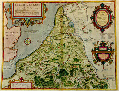
Title: BELGII VETERIS | TYPVS | "Ex conatibus geographicis Abrahami Ortelij". [A map of the ancient low countries, from the geographical efforts of Abraham Ortelius.] | HAC LITTERARVM FORMA, VETVSTIORA PINXIMVS. | Quæ paulo erant recentiora, his notauimus. | "Nulla autem antiquitate illustria, hoc charactere | Recentissima vero, his vernaculis ab alijs distinximus" [With this type we recorded the oldest [Roman] names [CAPITALS]. Those of later times with this type [lower case]. Names that do not derive from antiquity with this type [cursive lower case]. While for modern names we use this type [cursive fantasy font] to distinguish them from the others].(Oval cartouche upper right:) S[enatus].P[opulus].Q[ue].A[ntwerpiensis]. | PATRIAM AN:|TIQVITATI A SE | RESTITVTAM | DEDICABAT | LVB. MER. | ABRAHAMVS | ORTELIVS | CIVIS. (Around edge of cartouche:) NESCIO QVA NATALE SOLVM DVLCEDINE CVNCTOS DVCIT, ET IMMEMORES NON SINIT ESSE SVI. (Quote from Ovidius' "Ex Ponto 1,3,5). [With pleasure the citizen Abraham Ortelius dedicates this map of his native country to the senate and people of Antwerp; I do not know what has a sweet hold on all the native soil; it does not tolerate oblivion]. (Cartouche lower right:) "1584 | Cum priuilegio | Imperiali et Bel:|gico, ad de:|cennium". [With an imperial and Belgian privilege for ten years]. (Cartouche left bottom:) "Prisca vetustatis Belgæ monumenta recludit | Ortelius, priscas dum legit historias. | Collige prima soli natalis semina Belga, | Et de quo veteri sis novus ipse vide. | Favolius caneb". [By studying books on ancient history, Ortelius rediscovered the antique monuments of the Low Countries in Roman times; Collect, reader, the first grains of your native soil, and learn from which ancestors you are the offspring. From the poetry of Favolius] (a personal friend of Ortelius, physician and poet).
Plate size: 377 x 492 mm.
Scale: 1 : 1,400,000
Identification number: Ort 197 (Koeman/Meurer: 6P, Karrow: 1/154, vdKrogtAN: 3000H:31A).
Occurrence in Theatrum editions and page number:
1584L3Addblank or * (100 copies printed) (identical to 1584L, but here without page number; last line, centred, in cursive script: "Vocabulis locorum,quæ in hac tabula legentur,lucem dabit noster Thesaurus Geographicus".),
1584L101 (or occasionally 103) (750 copies printed) (identical with 1584L3Add, but here with page number; last line, centred, in cursive script: "Vocabulis locorum,que in hac tabula legentur,lucem dabit noster Thesaurus Geographicus".),
1584G3Add16 in upper right corner (75 copies printed) (last line, left aligned, in Gothic script: zu Graitz in Styrien/und zu Neaples.),
1585F3Add11 (75 copies printed) (last line, left aligned, after 3. in cursive script: "Virgile en ses Georg.liure 3. Mieux trainera aux affaires belgiques Le col domté,les chariots Belgiques".),
1587F101 (250 copies printed) (last line, left aligned: Belgium roy des Celtes. Nous laisserons ces choses à debatre à qui bon semblera.),
1592L6 (525 copies printed) (last line, left aligned, partly in cursive script: Virgilius Georg.1. "Belgica vel molli meliùs feret esseda collo". Lucan.lib.1. "Et docilis rector rostrati Belga couini".).
States: 197.1 as described.
197.2: in 1592 some place names were added and one place name was changed: along the coast lower left added: GESSORIACVS | PAGUS; centre: Quarta; low centre: AD FINES, and "Andagium"; right of centre: CORIOVALLVM, RUMANEHA and "Belsonancum. Cauburg" was replaced by CASTRA SARRÆ.
Approximate number of copies printed: 1775.
Cartographic sources: made by Ortelius on the basis of classical sources. The ones he mentions, notably Cæsar, deal with peoples and names, rather than with the geography of the area.
References: H.A.M. van der Heijden "Ortelius and the Netherlands", p. 271-290 in: M. van den Broecke, P. van der Krogt and P. Meurer (eds.) "Abraham Ortelius and the First Atlas", HES Publishers, 1998. H.A.M. van der Heijden "Old Maps of the Netherlands", 1548-1794, Canaletto, Alphen aan de Rijn, Netherlands, 1998, map 28, p. 200-202; H.A.M. van der Heijden (2004) "De bataafse mythe in de cartografie", in "Caert-Thresoor" 23.2, p. 37-41.
Remarks: This map was replaced in 1595L by plate Ort 198 which bears the date 1594.
For questions/comments concerning this page, please e-mail info@orteliusmaps.com.