Cartographica Neerlandica Background for Ortelius Map No. 193
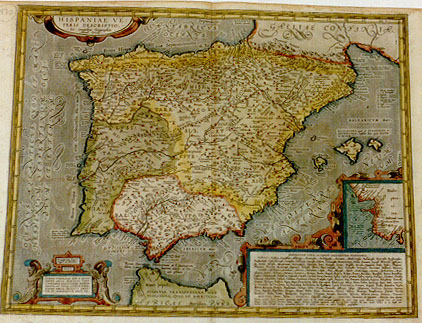
Title: HISPANIAE VE:|TERIS DESCRIPTIO. | "Ex conatibus Geographicis | Abrah. Ortelij". [A representation of ancient Spain from the geographical efforts of Abraham Ortelius]. (Cartouche bottom left:) "Priuilegio Imp. Reg. et | Belgico, ad decennium. | 1586". | SVMMO THEOLOGO DNO D. BENE:|DICTO ARIÆ MONTANO; VIRO | LINGVARVM COGNITIONE, RERVM | PERITIA, ET VITAE INTEGRITATE | MAGNO; ABRAH. ORTELIVS AMICITI:|TIÆ ET OBSERVANTIÆ ERGO, DD. [With an imperial, royal and Belgian privilege for ten years. 1586. Dedicated to the excellent theologist lord Benedictus Arias Montanus, a man well versed in languages, knowledgeable in matters, and with great integrity in life by Abraham Ortelius in friendship and due reverence]. (Cartouche bottom right:) HISPANIÆ LOCA ALIQVOT INCOGNITÆ POSITIONIS. [Some places in Spain of unknown location] (followed by 17 lines with peoples, places, mountains, rivers and sources of unknown location). (Inset, 80 x 70 mm:) GADES (Cadiz) and surroundings. (Left edge:) "OCEANVS ATLANTICVS, QVOD ET MARE | HESPERIVM, VESPERTINVM, OCCIDVVM, ET EXTERNVM". [Atlantic ocean, which is also called the sea of of the evening, the night, the west and the outer sea]. (Bottom centre:) "Fretum Herculeum, Gaditanum, et Columnarum. | Idem, Limen Interni maris, et Oce:|ani ostium". [The Herculean or Gaditane straits, also called the columns, the threshold of the internal sea and the mouth of the ocean].
Plate size: 375 x 494 mm.
Scale: 1 : 3,500,000.
Identification number: Ort 193ab (Koeman/Meurer: 20P, Karrow: 1/175, vdKrogtAN: 6000H:31)
Occurrence in Theatrum editions and page number:
1590L4Addblank (text and typesetting identical to 1592L but here without page number; last line, first text page, right aligned: tiliorem ; last line, second text page, left aligned, in cursive bold script except for the last 4 words: "illustre fortita ,paruis opidis habitatur,parua flumina emittit,solo quàm viris melior, & segnotie gentis obscura": nihil hic dicendum existimaui".),
1591G4Addblank (last line first text page, mostly in Gothic script, full width: "tiberi" sambt ihren benachbarten bei den mitternächtigen lenderen verehren einen unnamhafften Gott/ und daß bei nacht im vollen Mon/ das sie ; last line second text page, left aligned: niger von den "Poëten"/als "Iuuenale, Statio" und "Silio" beschrieben.) [This edition starts just above § 11.],
1592L4 (text and typesetting identical to 1590L4Add but here with page number 4; last line first text page, right aligned: tiliorem ; penultimate line: modi exempla plura ex auctoribus huc adduci. Sed hæc pauca de gentis genio sufficiant. & ad regionis, solique naturæ descriptionem accingamur. & primùm de eius fertilitate. Fer- ; last line second text page, left aligned, in cursive script except for the last four words: "illustre fortita ,paruis opidis habitatur,parua flumina emittit,solo quàm viris melior, & segnotie gentis obscura": nihil hic dicendum existimaui.),
1595LD (last line first text page, right aligned: aut; penultimate line: bus huc adduci.Sed hæc pauca de genus genio sufficiant.& ad regionis, solique naturæ descriptionem accingamur & primum de eius fertilitate. Fertiliorem eam facit Trogus Africâ ; last line second text page, mostly in cursive script: "stre fortita paruis opidis habitatur, parua flumina emittit,solo quàm viris melior, & segnitie gentis obscura": nihil hic dicendi estimaui.),
1601Lx (last line first text page, right aligned: torquentium ; last line second text page, left aligned, mostly in cursive script: "stre fortita,paruis opidis habitatur,parua flumina emittit solo quam viris melior,& sognitie gentis obscura:" [normal script:] nihil hic dicendum existimaui.),
1602G10? (no evidence of inclusion of this map in the 1602G edition.),
1603Lx (text and page number, but not typesetting, identical to 1609/1612L/S ; last line first text page, right aligned: se in ; last line second text page in cursive script except for the last four words: "illustre fortita,paruis opides habitatur,parua flumina emittit. solo quàm viris melior,& segnitie gentis obscura:" nihil hic dicendum estimaui.),
1606Ex (last line, first of four text pages, italic like the entire text, full width: "tion of the washing of their teeth.We read in Diodorus Siculus,that at their meales they eat lustily upon sundry dishes,that they make their drink of hony, | and"),
1608/1612Ix (last line first text page, right aligned: co- ; last line second text page, left aligned: tito alcuna cosa d'illustræ , & è habitata in piccole terre, & manda fueta piccole fiumane, migliore di terreno, che d'huomini, & per la pigtitia della gente oscura, quiui non ho giudicato dirne altro.),
1609/1612L/Sx (text in Latin; text and page number, but not typesetting, identical with 1603L; last line first page, right aligned, in very small font: gum. liber- ; last line second page, left aligned, very small font, italic except for the last 4 words: "illustre fortita,paruis opidis habitantur,parua flumina emittit. solo quàm viris melior, & segnitie gentis obscura:" nihil hic dicendum extimaui.),
1619BertiusSS (last line first text page, right aligned: ex melle ; last line second text page, right aligned: cant)(some Bertius atlases have Ort193 here, others only use the text which was taken from the 1609/1612L/S Theatrum but reset, but with the Hondius map of ancient Spain used on the map side of the sheet.),
1624L Parergon/1641Sxiij, xiiij (last line second column first text page: cero in quadam Oratione scribit , Romanos, hos | non ; last line second column second text page: simili, vt illud ad quæuis fortunæ incerta in prom-|tu).
States: 193.1 as described.
193.2: from 1601 onwards: "Barbarium prom" was added south of the mouth of the river Tagus, and the lettering in the sea everywhere was filled in with stippling. The place name "Cinnaria" at the beginning of the 8th line of places of uncertain location, bottom right, was crossed out correctly because it is presented in section E1.
Approximate number of copies printed: 3550.
Cartographic sources: made by Ortelius on the basis of modern information from Clusius' six-sheet map of Spain which appeared in 1571, (Meurer p. 127-129) and ancient knowledge from Strabo, Appianus, Livius, Valerius Maximus and Suetonius. In 1593 Barbosa asks Ortelius (Hessels 240, 258) to correct some place names.The second letter (1594) indicates that these corrections have been carried out.
References: A. Hernando "The contribution of Ortelius' Theatrum to the Geographical Knowledge of Spain." p. 239-262 in Van den Broecke, van der Krogt & Meurer (eds.) "Abraham Ortelius and the First Atlas", 1998, HES Publishers.
Remarks: Bertius bought a number of sheets with this map and included the map in his historical 1619 atlas "Theatrum Geographiæ Veteris".
A close copy of this map was produced by Schottus in his work Hispaniæ Illustratæ seu rerum Urbinumque Hispaniæ, Lusatiæ, Æthiopiæ et Indiæ Scriptes Varii, 4 vols., Frankfurt 1603-1608.
For questions/comments concerning this page, please e-mail info@orteliusmaps.com.