Cartographica Neerlandica Background for Ortelius Map No. 188
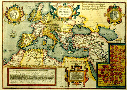
Title: ROMANI/IMPERII/IMAGO. [= An image of the Roman Empire] (bottom centre:) Cum Gratia et/Priuilegio [= with grace and privilege] (lower left and middle two cartouches with 14 lines and 8 lines of text concerning Roman history, and right bottom a genealogical tree of Roman kings). (Top right:) Divina mens civitatem populi/Romani egregia temperataq re:/gione collocavit, uti Orbis terra:/rum imperio potiretur. Vitruvius lib. 8. [= The divine mind has assigned the citizens of the Roman nation an excellent and temperate region, so that they could establish the Empire of the whole world. Vitruvius Book 8.]
Plate size: 349 x 498 mm.
Scale: 1 : 15,000,000
Identification number: Ort 188 (not in Koeman, Meurer or Karrow, vdKrogtAN: 1050H:31B).
Remarks: when I published the book "Ortelius Atlas Maps" in 1996, I encouraged readers to send me information on new plates and new states not described in my book. As a result, I have received much information on new states and found quite a few myself as well, which have meanwhile been incorporated on this website.
However, inventive and meticulous research by Joe Q. Walker has demonstrated that I postulated too many new plates, rather than too few.
When I postulated in 1996 a new plate Ort 188 Romani Imperii my main argument for deciding that this was a new plate consisted of the fact that this offprint Ort 188 showed small blocks of diagonal hachuring, where Ort 187 showed diagonal hachuring in the opposite direction. I assumed that it was technically not feasible to erase such small patches of hachuring on the copperplate and replace these patches with hachuring in a different direction. The observation was correct but the conclusion was wrong.
Walker has demonstrated that the new hachuring was applied on top of the old one. He also demonstrates that plate blemishes such as scratches and spurious dots occurring on Ort 187 also occurred on plate Ort 188. Therefore, the existence of a separate plate Ort 188 cannot be upheld. Walker has published the arguments leading to this conclusion in detail in a monograph "The Maps of Ortelius and their Variants", Antiquarian Maps Research Monographs - 1, which can be obtained from him on request through Email Martran@msn.com.
I am happy that I have been informed about this research, since it increases our knowledge on Ortelius' maps.
No map text available
No bibliographical sources available
No topographical names available
For questions/comments concerning this page, please e-mail info@orteliusmaps.com.
The software that generates this website is available for sale. For more information, contact Thomer M. Gil.
This page has been generated on Tue Nov 18 09:48:33 2008.