Cartographica Neerlandica Background for Ortelius Map No. 18
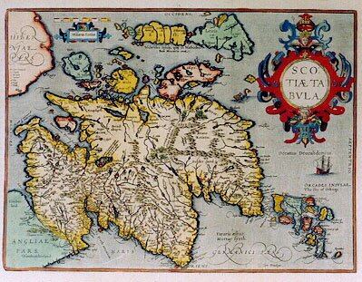
Title: SCO:|TIĆ TA:|BVLA. [A Map of Scotland] (lower right:) "cum priuilegio". [with privilege]. "L. Nessa, neque | flu Neßa unquam congelator" [Loch Ness and the river Ness never freeze]. "Lacus Lomond, magnis | tempestatibus obnoxius | est, et in eo pisces | pinnis carent". [there are obnoxious tempests in Loch Lomond, and its fish have no bones].
Plate size: 357 x 478 mm
Scale: 1 : 1,150,000
Identification number: Ort 18 (Koeman/Meurer: 54, Karrow: 1/78, van der Krogt AN: 5800:31).
Occurrence in Theatrum editions and page number:
1573L1Add6.A. (100 copies printed) (identical with 1573L, but different page number; last line, centred like one line above it: De Scotia & insulis vicinis,lege quos hoc loco citauimus,Hectorem Boethium,& Ioannem Maiorem,Scothos.),
1573D1Add6A/1573D6A (150 copies printed) (last line, centred like 7 lines above it, in Gothic script: behooren.),
1573L7 (75 copies printed) (Version A identical with 1573L1Add, but with different page number; first line ends with: reti- ; version B has first line ending with: linguam ; both versions have last line, centred like one line above it: De Scotia & insulis vicinis,lege quos hoc loco citauimus,Hectorem Boethium,& Ioannem Maiorem,Scothos.),
1573G1Add/1573G6A (150 copies printed) (last line, centred like 6 lines above it: welche beid Schotlćnder gewesen.),
1574F1Add/1574F6A (125 copies printed) (last line, centred like 3 lines above it: qu'aiant le tiltre de Duché elles sont sous le Roiaume d'Escosse.),
1574L7, (175 copies printed) (large page number, 11 mm; first text line ends: linguam reti- ; last line, centred like one line above it: De Scotia & insulis vicinis, lege quos hoc loco citauimus, Hectorem Boęthium,& Ioannem Maiorem, Scotos.),
1575L7 (100 copies printed) (small page number, 7 mm; first text line ends: linguam re- ; last line, centred like one line above it: De Scotia & insulis vicinis , lege quos hoc loco citauimus, Hectorem Boëthium,& Ioannem Maiorem, Scotos.),
1579L(A)9 (250 copies printed) (last line, centred like one line above it: De Scotia & insulis vicinis, lege quos hoc loco citauimus, Hectorem Boëtium, & Ioannem Maiorem,Scothos.),
1579L(B)9 (250 copies printed) (last line, left aligned: nem Maiorem,&Ioannem Leslćum,Scotos. one but last line: sub Ducatus titulo sciamus. De Scotia & insulis vicinis, lege quos hoc loco citauimus, Hectorem Boëthum,& Ioan-),
1580/1589G9 (350 copies printed) (last line, partly in Gothic script, left aligned: nemlich Hectorem Boethium,vń Ioannem Maiorem, welche beyde selbst Schottländer gewesen seindt.),
1581F9 (400 copies printed) (last line, left aligned: Danemarc,& toutefois nous sçauons bien qu'ayant le tiltre de Duché elles sont sous le Royaume d'Escosse.),
1584L10 (750 copies printed) (last line, left aligned: nem Maiorem,& Ioannem Leslćum,Scotos.),
1587F10 (250 copies printed) (last line, left aligned: Danemarc, &toutefois nous sçauons bien qu'ayant le tiltre de Duché elles sont soubs le Royaume d'Escosse.),
1588S10 (300 copies printed) (last line first text page, right aligned: en Scocia ; last line second text page, left aligned: leer a los que nos aqui hemos citado, Hector Boëtho, y Ioan Mayor, y Ioan Leslćo, Escocezes.),
1589G9 see 1580G,
1592L11 (525 copies printed) (page number under the first letter of Maiorem in the one but last line; last line, left aligned: Leslćum, Scotos.},
1595L11 (500 copies printed) (page number under & between Maiorem and Ioannem in one but last textline; last line, left aligned: Leslćum, Scotos.},
1598/1610/1613D12 (100 copies printed) (last line, left aligned, in Gothic script: Schotlandt met een tytel eens Hertogdoms behooren.),
1598F11 (525 copies printed) (last line, full width: soubs les Roys de Danemarc,& toutefois nous sçauős bien qu'ayăt le tiltre de Duché ellessont soubsle Royaume d'Escosse.),
1601L11 (200 copies printed) (last line, left aligned: hos quos superiůs citauimus,Hectorem Boëthum, & Ioannem Maiorem, & Ioannem Leslćum, Scotos.),
1602G11 (250 copies printed) (last line, left aligned, in Gothic script like the entire text: selbst Schottländer gewesen seindt.),
1602S11 (250 copies printed) (one but last line, left aligned: bien el azul que llaman lazur. Tambien tiene minas de hiero y de plomo. Last line, right aligned: Los; last line second text page, left aligned: y loan Mayor,y Ioan Leslćo,Escocezes.),
1603L11 (300 copies printed) (last line, left aligned: Boëthum, & Ioannem Maiorem, & Ioannem Leslćum,Scotos. Text and typesetting identical to that of the 1609/1612L edition, but page number 11 is located below the word citauimus in one but last line),
1606E11 (300 copies printed) (last line, left aligned: in "Hector Boëthius, Iohn Maior", and "Iohn Lisley", Scottish-men which haue written the histories of this their country.),
1608/1612I11 (300 copies printed) (last line, left aligned: Boeto, Giouanni Maggiore, & Giouanni Lesleo Scozzesi si puo leggere ŕ sufficienza.),
1609/1612L11 (300 copies printed) (last line, left aligned: Boëthum, & Ioannem Maiorem, & Ioannem Leslćum,Scotos. Text and typesetting identical with that of the 1603L edition, but page number 11 is for this edition located below the space between the word superius and citauimus in the one but last text line.),
1609/1612/1641S11 (325 copies printed) (last line first text page, right aligned: dad, ; last line second text page, left aligned: aqui hemos citado,Hector Boëto,y Ioan Mayor,y Ioan Leslćo,Escocezes.),
Approximate number of copies printed: 7300.
States: 18.1 as described.
18.2: in 1598F the hachuring on coastlines was extended from about 3 to about 6 mm; ornaments around cartouche circle receive shading.
18.3: after 1598 and before 1601L, dots added around sea names. The place name "S. Iohns" has been added beneath "Sckone" just above the A of Angusia, lower left, about 20 miles North of Edinburg (B3).
Remarks: this map is essentially an enlarged part of the British isles map, Ort16. Next to "Orcades insulć" "The iles of Orkney" have been added. "Cardenbrog" has been changed to "Carndeburg" and North of the Hebrides the Isle of Rona has been added.
Cartographic sources: Mercator's 1564 wall map of the British isles in 8 sheets (Meurer p. 197, Karrow 56/16, p. 387-388).
References: D.G. Moir (1973) The Early Maps of Scotland Volume I, Royal Scottish Geographical Society, Edinb., pp. 14-16, 24-26, 164.
For questions/comments concerning this page, please e-mail info@orteliusmaps.com.