Cartographica Neerlandica Background for Ortelius Map No. 179
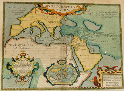
Title: (in cartouche:) GEOGRAPHIA | SACRA. [Holy Geography.] (Top right:) "Ex Conatibus geographicis Abrahami | Ortelij, Cum priuilegio Imp. Regis, et | Cancellarić Brabantić, ad decennium". | mdxcviii. [From the geographical efforts of Abraham Ortelius, with an imperial, royal and Brabant privilege for ten years, 1598.] (Cartouche lower left:) "Ophiram | regionem quia hćc | tabula comprćhen:|dere non poterat, hanc aream univer:|salem hic seorsim delineavimus, in qua illam | ex dissentientium scriptorum iudicio notavimus. | Nostram vero de eadem sententiam si quis | intelligere aveat, Thesaurum nostrum | Geographicum adeat, censu:|ramosque suam (per me | enim licebit) | addat". [Because this map could not include the Ophira region, we have presented this world map separately, on which we have noted disagreements in judgment of [different] writers. If anyone desires to know our true opinion about this matter, let he turn to our Geographical Treasure as we think, if he allows me, for additional information.] (Upper left:) Mare positum est in spaci:|oso loco, ut esset altum et immensum. | 4. Esdrć, cap. 7. [The sea has been located in a spacious place, as if it were very deep and large, 4 Esdrć chapter 7 [Old testament]].(Inset: small world map 62 x 102 mm.) "Hćc notula locum | Ophirć designat". [This small map represents the locations of Ophyra.] (Surrounding text:) DOMINI EST TERRA ET PLENITVDO ORBIS TERRARVM ET VNIVERSI QVI HABITANT IN EO "Psal. 24". [The land and vastness of the world and those living on it belong to the Lord, Psalm 24]. (Cartouche bottom right:) REVERENDO ET ILLVSTRI | DNO GVILELMO GRIM:|BERGIO, ANTVERPIENSI | PRĆSVLI DIGNISSIMO | Abrah. Ortelius obse:|quij devotionisque ergo | dedicab. consecrabatque. [Abraham Ortelius dedicates and recommends it therefore obediently and devotedly to the reverend and illustrious gentleman Guilelmus Grimbergen, the most dignified chairman of Antwerp.] (In Red sea:) "Asion Gaber, unde in | Ophiram nauigabant". [Asion Gaber, from here they sailed to Ophira.] (In Persian gulf:) "Hydaspis fluvius, qui Phison | Niceph, Callisto, Phison alijs, | Ganges est, quem hćc ta|bula capere haud | potuit". [The river Hydaspis, which is considered to be the Phison by Nicephorus Callistus and by others the Ganges, which this map cannot contain].
Plate size: 356 x 482 mm.
Scale: 1 : 15,000,000.
Identification number: Ort 179 (not in Koeman, Meurer or Karrow, vdKrogtAN: 0810:31B).
Occurrence in Theatrum editions and page number:
1601Lj (100 copies printed) (last line, left aligned: rergo nostro TABVLA.),
1603Lj (300 copies printed) (text and page number, but not typesetting, identical to 1609/1612L; last line, full width: situm cognosces ex alia nostra ĆVI VETERIS GEOGRAPHIĆ,in hoc Parergo nostro TABVLA.),
1606Ej (300 copies printed) (last line, left aligned: our bye-worke, intituled "Ćui veteris Geographić tabula", A Geographicall chart of the old World.),
1608/1612Ij (300 copies printed) (last line, full width, in cursive script like the entire text: "sito di lui vedrai da vn'altra nostra di questa giunta, che si dice Tauola di Geografia dell'esta antica."),
1609L/1612L/Sj (300 copies printed, text in Latin) (last line, left aligned: tem situm cognosces ex alia nostra ĆVI VETERIS GEOGRAPHIĆ in hoc Parergo nostro TABVLA.),
1624LParergon/1641Sj [but in Latin] (1025 copies printed) (text in two columns; last line second column: tergo nostro TABVLA.).
Approximate number of copies printed: 2625.
States: 179.1 only.
Cartographic sources: this map of Sacred Geography is based on holy writers in the Old and the New Testament, following the translation of the Septuaginta. For details, the reader is referred to other Parergon maps, notably the travels of Abraham and St. Paul.
Remarks: Originally I was of the opinion that Ort178 was the predecessor of this map, but that map turned out to be a close copy of this map made by Janssonius, which has no cartouche around the title.
For questions/comments concerning this page, please e-mail info@orteliusmaps.com.