Cartographica Neerlandica Background for Ortelius Map No. 15
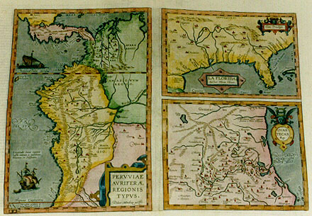
Title: PERVVIAE | AVRIFERĆ | REGIONIS | TYPVS. | "Didaco Mendezio auctore" - LA FLORIDA. | "Auctore Hieron. Chiaves". [Image of Peruvia, a gold-producing region. By Diego de Mendez - Florida by Geronimo Chiaves. (cartouche top right:) "Cum Priuilegio." [With Privilege] - GVAS:|TECAN | "Reg". [The Guastecan Region]. (Textblock lower left:) "Longitudo huius regionis | habet initium ŕ meridiano | Toletano, in Hispania". [The longitude of this region starts at the meridian of Toledo in Spain]. (Text block lower left:) "Hć insulć primum de:|tecta fuere ao 1574." [These islands were first discovered in 1574].
Plate size: 337 x 466 mm. For sizes of each map see below. Three maps on one plate.
Identification number: Ort 15, Koeman/Meurer 103a-c, Karrow 1/133-1/135)
Title Ort 15a: Peruvić
Scale: 1 : 13,000,000. Size: 337 x 223 mm.
Identification number: Ort 15a (Koeman/Meurer: 103a, Karrow: 1/133, van der Krogt AN: 9820:31)
States: 15a.1.
15a.2 after 1592 and before 1595 all horizontal hachuring along coast lines was extended from 1.5 to 3 mms.
Note that the lower left corner of the plate broke off between 1602 and 1603, (8 x 13 mm) partly obliterating the island of S. Felicis.
Cartographic sources: Didacus Mendezius, mentioned on the plate as the author of this map, is relatively unknown in cartographic history. Possibly, it derives from Don Diego Hurtado de Mendoza, a philologist (Meurer p. 194). A more likely candidate is Diego Méndez or Didaco Mendezio, chaplain of the monastery of the Incarnation in Lima, and cartographer for the viceroy of Peru.
Remarks: a stamp showing this Peru map was issued in Peru in 2003 to commemorate 100 years of diplomatic relations between Peru and Panama.
Title Ort 15b: Florida
Scale: 1 : 14,500,000. Size: 155 x 225 mm.
Identification number: Ort 15.b1 (Koeman/Meurer: 103b, Karrow: 1/134, van der Krogt AN: 9440:31).
States: 15b.1.
15b.2: after 1592 and before 1595 all horizontal hachuring along coast lines was extended from 1.5 to 3 mms.
Cartographic sources: Geronimo de Chaves, who based himself on the Casa de Contratacion, Hernando de Soto (Karrow 20/7, p. 118, Meurer p. 127).
Title Ort 15c: Guastecan
Scale: 1 : 1,700,000. Size: 176 x 224 mm.
Identification number: Ort 15c (Koeman/Meurer: 103c, Karrow: 1/135, van der Krogt AN: 9540:31)
States: 15c.1.
15c.2: after 1592 and before 1595 all horizontal hachuring along coast lines was extended from 1.5 to 3 mms.
Cartographic sources: unknown (Meurer p. 92)
Occurrence in Theatrum editions and page number:
1584L3Addblank (100 copies printed) (identical to 1584L, but here without page number; last line, left aligned: alter rubeam, sed valde feruentem.),
1584G3Add8 page number in upper right corner (75 copies printed) (last line, left aligned, in very small Gothic font: gar heysses außgeusst.},
1585F3Add16 (75 copies printed) (last line, left aligned: taigne oů il a deux fontaines, desquelles l'vne des gorge de la poix fort noire, l'autre rouge, mais fort chaude.),
1584L8 (750 copies printed) (identical to 1584L3Add, but here with page number; last line, left aligned: alter rubeam, sed valde feruentem.),
1587F8 (250 copies printed) (last line, left aligned: oů il y a deux fontaines , desquelles l'vne desgorge de la poix fort noire, l'autre rouge , mais fort chaude.),
1588S8 or blank (300 copies printed) (last line first text page, right aligned: antes ; last line second text page, left aligned: les la vna mana pez muy negra , la otra bermeja y muy hiruiente.),
1592L9 (525 copies printed) (last line, left aligned: feruentum),
1595L9 (500 copies printed) (last line first text page on verso map, right aligned: Cuxi ; one but last line first text page: que.)Hic moriens filium hćredem instituit XAIREM TOPAM Ingam,qui duxit in vxorem Coyam; last line second text page, left aligned: beam ,sed valde ferventem.),
1598/1610/1613D9 (100 copies printed) (last line, first text page, right aligned, Gothic script: leucken| ; last line second text page, in Gothic script, left aligned: op zijn|daer d'eene swerten Peck uyt werpt|d'andere rooden|dan seer heet ende siedende.),
1598F9 (525 copies printed) (last line, left aligned: ily a deux fontaines,desquelles l'vne desgorge de la poix fort noire, l'autre rouge, mais fort chaude.),
1601L9 (200 copies printed) (last line first text page, right aligned: nomen ; last line second text page, full width: mons visitur,in quo duo fontes,quorű alter picem nigerrimam effundi;alter rubeam,sed valde feruentem.),
1602G9 (250 copies printed) (last line, left aligned, in Gothic script like almost the entire text: deren einer uber auss schwartzes|der ander aber roten|gar heysses Pech außgeusst.),
1602S9 (250 copies printed) (last word, right aligned, first text page: peus; last line, left aligned, second text page: y muy hiruiente.),
1603L9 (300 copies printed) (last line second first text page, right aligned: pa ; second text page, left aligned : visitur, in quo duo fontes, quorum alter picem nigerrimam effundit;alter rubeam, sed valde feruentem.),
1606E9 (300 copies printed) (last line first text page: men, penultimate line, full width: niards. This was the end of these two brothers. Whereupon MANGO "Inga", a third brother tooke the gouern),
1608/1612I9 (300 copies printed) (last line, left aligned: alla terra di Tamatao si vede vn monte, nel qual due fontane sono, l'vna manda fuori pece negrissima, & l'altra rossa, molto bollenti.),
1609/1612/1641S9 (325 copies printed) (last line first text page, right aligned: dio,y; penultimate line: samalea,y Guascar en Cusco: Atabalipa salio contra su hermano con exercito y alcâçada la victoria leprę-),
1609/1612L9 (300 copies printed) (last line first and only text page, left aligned: rubeam,sed valde feruentem.).
Approximate number of copies printed: 5425.
References: Burden (1996) "The Mapping of North America", map 57, p. 71-73. D. Reinhartz "The Americas Revealed in the Theatrum", p. 209-220 in: Van den Broecke, van der Krogt and Meurer (eds) "Abraham Ortelius and the First Atlas", HES Publishers, 1998.
For questions/comments concerning this page, please e-mail info@orteliusmaps.com.