Cartographica Neerlandica Background for Ortelius Map No. 134
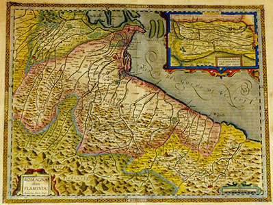
Title: ROMAGNA, | olim | FLAMINIA: | "Auctore Ioan. Antonio Magino." [Romagna, once called Flaminia, by Ioannes Antonius Magini].
(Inset 110 x 165 mm, scale 1 : 300,000:) RHODINGINĆ PENIN:|SVLĆ DESCRIPTIO: | "Auctore Gaspare Bonifacio." [A representation of the Rhodingina Peninsula by Gaspar Bonifacius].
Plate size: 374 x 491 mm.
Scale: 1 : 300,000
Identification number: Ort 134 (Koeman/Meurer: 158, not in Karrow, vdKrogtAN: 7370:31).
Occurrence in Theatrum editions and page number:
1608/1612I92 ((300 copies printed) last line first text page, left aligned: e tra questi Giouanni detto communemente da Imola,& Alessandro Tartagno,famosissimi giurisconsulti. ; last line second text page, left aligned: gono honorate memorie di Rouigo & di tutto questo Polesine.),
1609/1612L93 (300 copies printed) (last line, first text page, right aligned: Ab alio; last line second text page, in cursive script, left aligned: "dit, aliosq".),
1609/1612/1641S93 (325 copies printed) (last line first text page, right aligned: POLE- ; last line second text page, left aligned, in cursive script like the entire page: "y de todo el Polesine".).
Approximate number of copies printed: 925.
States: 134.1 only.
Cartographic sources: this map is based on the single sheet map of the Romagna area which Giovanni Antonio Magini (1555-1617) drew and published in 1597 (Meurer p. 189). The inset map of the area around Rovigo-Adria in Polesina, hardly a peninsula although characterised as such, derives from Giovanni, rather than Gaspar Bonifacio (1547-1635), who sent a map of this area to Pigafetta around 1602. After his death in 1604, Pigafetta's material came into the hands of Vrients (Meurer p. 117-118, 214).
For questions/comments concerning this page, please e-mail info@orteliusmaps.com.