Cartographica Neerlandica Background for Ortelius Map No. 133
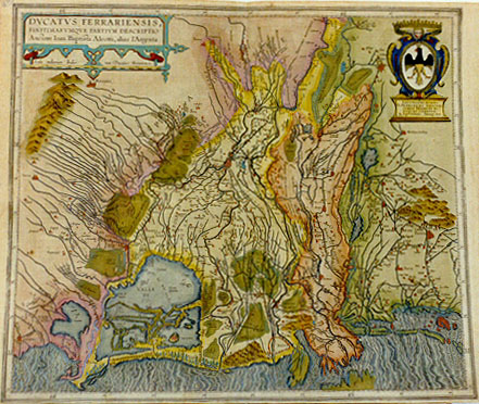
Title: DVCATVS FERRARIENSIS, | FINITIMARVMQVE PARTIVM DESCRIPTIO: | Auctore Ioan. Baptista Aleotti, alias l'Argenta. [A representation of the duchy of Ferrara, its parts and borders, by Ioannes Baptista Aleotti, also called Argenta]. (Cartouche upper right:) ILLVSTRISSIMO DOMINO | D. HIERONYMO GILIOLIO | COMITI TRIGNANI &c. | PATRONO COLENDISS. | "Io. Bapts. Vrintius Antverp. DD." [Dedicated by Ioannes Baptista Vrients of Antwerp to the most illustrious Lord Hieronymus Giliolius of the area of Trignanus etc., patron of faith].
Plate size: 445 x 516 mm.
Scale: 1 : 500,000
Identification number: Ort 133 (Koeman/Meurer: 157, not in Karrow, vdKrogtAN: 7390:31).
Occurrence in Theatrum editions and page number:
1608/1612I91* (300 copies printed) (last line, left aligned: non esserui chi n'habbia cura.),
1609/1612L92 (300 copies printed) (last line, first text page, right aligned: tur., last line, second text page, centred and in capitals : PONI MANDAVIT. M. DC. II.),
1609/1612/1641S92 (325 copies printed) (last line first text page, right aligned: CLEMEN- ; last line second text page, centered, in capitals like the entire page: PONI MANDAVIT. M. DC. II.).
Approximate number of copies printed: 925.
States: 133.1 only.
Cartographic sources: Giovanni Battista Aleotti (1546-1636) made a single sheet map of the Ferrara area in 1603 which served as a model for the present map (Meurer p. 101-102).
For questions/comments concerning this page, please e-mail info@orteliusmaps.com.