Cartographica Neerlandica Background for Ortelius Map No. 10
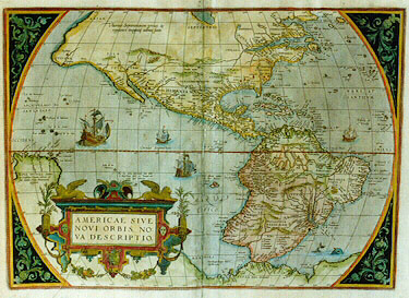
Title: AMERICAE SIVE | NOVI ORBIS, NO:|VA DESCRIPTIO. [A new description of America or the New World].(lower right below sea monster:) "Cum priuilegio". [with privilege]. (Middle left:) "NOVA GUINEA Andre|as Corsalus Florent: videtur eam|sub nomine Terre |Picinnacoli designare. [Andreas Corsalus from Florence seems to refer to this land as Picinnacoli]. (Centre left:) "Hae duae insulae infortunatae sunt dictæ | a Magellano, quod nec homines nec | victui apta haberent". [These two islands are called the unfortunates ones by Magellan because they are not suitable to provide food for humans]. "Hic uspiam insulas | esse, auro diuites | nonnulli | volunt. [Somewhere here are the islands which some claim to be rich of gold.] (Upper left:) "Ulterius Septentrionem versus hae | regiones incognitæ adhuc sunt." [These Northern most regions are to this day unknown].
Plate size: 357 x 496 mm
Scale: 1 : 40,000,000
Identification number: Ort 10 (Koeman/Meurer 112/I (should have been 93/I); not in Karrow, vdKrogtAN: 9000:31B)
Occurrence in Theatrum editions and page number:
1579L(A)5 (250 copies printed) (second line begins "Orbis hodie", 13th line from the bottom begins: ria rerum Atlanticarum ; 6th line from the top ends: tentante ,quò iis),
1579L(B)5 (250 copies printed) (second line begins "Orbis hodie", 13th line from the bottom begins: ria rerum Atlanticarum ; 6th line from the top ends: tentante, quò iis),
1580G5 (175 copies printed) (last line, not in Gothic script in contrast to most of the text, in two columns: Antonius Mendoza (next column:) Ioannes Stadensis, [in Gothic script:] Teutsch.),
1581F5 (400 copies printed) (last line, left aligned: estant de couleur rousse),
1584L5 (750 copies printed) (13th line from bottom: mentaria rerum Atlanticarum:Idem Fredericus Furius Cæriolanus.),
few 1587F5 (150 copies printed), (last line: Asne,& la façon bien pres d'vne Chameau,estant de couleur rousse.).
Approximate total number of copies printed: 1975.
States: we know 10.1 only.
Cartographic sources: Gerard Mercator's 1569 world map (Karrow 56/17, 56/18 p. 390-393, Meurer p. 38).
References: Ph. D. Burden (1996), "The Mapping of America 1511-1670", p. 65, map 52; further: D. Reinhartz "The Americas Revealed in the Theatrum", p. 209-220 in: Van den Broecke, Van der Krogt and Meurer (eds) "Abraham Ortelius and the First Atlas", HES Publishers, 1998.
Remarks: This map succeeds plate Ort 9. It is very similar to that plate, but the ships are different. Here, the viewer looks into the sails of the leftmost ship, instead of the sails bulging towards the viewer, as is the case in the early plate 9. The frame no longer contains a clear chain-like structure with largish eyes and links as in plate 9, but now has small unconnected circle-like figures. It is succeeded in its turn in 1587 or slightly later by plate 11, which no longer shows the bulge in South America's west coast.
The poem included in the text below beginning with "Saxa volventur" (paragraph 18-21) also occurs in the "Paraphrase de Galien" written by Michel de Nostre Dame.
For questions/comments concerning this page, please e-mail info@orteliusmaps.com.